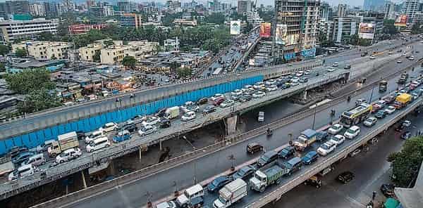
Chembur has spent the last decade and a half reinventing itself. What was once considered a somewhat overlooked eastern suburb — unfairly overshadowed by Bandra, Andheri, and the western corridor’s commercial glamour — has emerged as one of Mumbai’s most genuinely well-connected and fast-appreciating residential and commercial zones. The Eastern Freeway changed things considerably, and so did the Monorail. But Amar Mahal Junction and its flyover have been quietly managing the traffic implications of all this growth long before the newer infrastructure arrived, serving as the primary road junction where Chembur West’s internal arterials meet the Eastern Express Highway and the roads leading toward Sion, Kurla, and Govandi.
The flyover at Amar Mahal Junction handles a genuinely complex traffic geometry — vehicles transitioning between the Eastern Express Highway, the roads heading into Chembur’s residential interior, and the arterials leading toward Govandi and the eastern suburbs need to negotiate a junction that carries both local and through traffic in substantial volumes. For the large residential population of Chembur West, Tilak Nagar, and the surrounding colonies, this flyover is part of the daily commute in a way that makes its smooth functioning essential rather than optional.
Amar Mahal Junction Flyover Overview
| Detail | Information |
| Location | Amar Mahal Junction, Chembur West, Mumbai, Maharashtra |
| Primary Road | Eastern Express Highway / Chembur-Sion Road |
| Nearest Metro Station | Chembur — Mumbai Metro Line 2B |
| Nearest Monorail Station | Chembur — Mumbai Monorail Line 1 |
| Key Roads Connected | Eastern Express Highway, Sion-Chembur Road, Govandi Road, Tilak Nagar Road |
| Distance from CST / City Centre | Approx. 12–15 km |
| Distance from Kurla | Approx. 4–5 km |
| Distance from BKC | Approx. 6–8 km |
| Governing Authority | BMC, MSRDC, MMRDA |
| Nearby Landmarks | RCF Colony, Tilak Nagar Market, Chembur Gymkhana |
| Structure Type | Elevated Road Overpass / Flyover |
| Public Transport Options | Mumbai Metro Line 2B, Monorail, BEST Bus, App Cabs |
| Best Suited For | Eastern Express Highway and Chembur West corridor traffic |
| Peak Traffic Hours | 8:00 AM – 10:30 AM and 5:30 PM – 9:30 PM |
Directions to Amar Mahal Junction Flyover
From CST / Fort Area: Take the Eastern Express Highway northward from the Sion flyover heading toward Chembur. Continue past Sion and the highway’s eastern corridor approaching Amar Mahal Junction approximately 12 to 15 kilometres from CST. Travel time is approximately 25 to 40 minutes depending on highway traffic conditions.
From BKC / Kurla: Travel eastward from BKC via the Kurla connector and approach the Eastern Express Highway heading north. Continue along the highway toward Chembur. Amar Mahal Junction is approximately 6 to 8 kilometres from BKC with a travel time of 20 to 35 minutes.
From Govandi: Travel westward from Govandi along the Govandi Road heading toward Chembur West. Amar Mahal Junction is approximately 3 to 4 kilometres from Govandi’s residential areas, accessible within 10 to 20 minutes by road.
From Thane: Take the Eastern Express Highway heading southward from Thane through Mulund, Bhandup, and Ghatkopar. Continue southward and approach Amar Mahal Junction from the northern direction. Total distance from Thane is approximately 20 to 25 kilometres.
From Navi Mumbai via Sion-Panvel Expressway: Travel along the Sion-Panvel Expressway westward and connect to the Eastern Express Highway near Chembur. Amar Mahal Junction is accessible within 5 to 8 kilometres of the Sion-Panvel expressway connector. This route is particularly used by Navi Mumbai residents commuting into Central and South Mumbai.
Metro and Public Transport Connectivity
Chembur Metro Station on Mumbai Metro Line 2B has transformed the public transport profile of this junction significantly, connecting the Amar Mahal area westward through BKC, Dharavi, and Bandra, and providing the eastern suburbs a direct metro link to Mumbai’s most commercially important district. The Mumbai Monorail’s Chembur Station — where Line 1 originates — adds a further rail layer, connecting Chembur toward Jacob Circle via the Wadala corridor. BEST bus services operate multiple routes through the Amar Mahal Junction, connecting Chembur West to Kurla, Sion, Ghatkopar, and the broader eastern suburbs network. App-based cabs are well-supplied throughout this corridor given Chembur’s growing professional residential population.
Road Connectivity
- Eastern Express Highway runs north to south connecting Thane and the northern suburbs to CST and South Mumbai.
- Sion-Chembur Road connects westward toward Sion and the central Mumbai arterial network.
- Govandi Road extends eastward toward the Govandi and Mankhurd residential zones.
- Tilak Nagar Road provides access into Chembur West’s established residential interior.
Nearby Areas and Neighbourhoods
Tilak Nagar: One of Chembur West’s most established and community-oriented residential localities, Tilak Nagar is known for its strong Maharashtrian community character, local markets, temples, and the kind of neighborhood solidarity that older Mumbai suburbs do particularly well.
RCF Colony: The Rashtriya Chemicals and Fertilizers staff colony is one of Mumbai’s most distinctive residential enclaves — a well-maintained green township with schools, hospitals, and community facilities that has existed within Chembur’s fabric for decades.
Chembur Gymkhana Area: The Chembur Gymkhana and its surrounding residential zone represent one of the locality’s more premium addresses, popular among professionals and established families who value Chembur’s relatively better air quality and green cover compared to more central Mumbai neighborhoods.
Govandi and Shivaji Nagar: The eastern localities of Govandi and Shivaji Nagar are directly connected to Amar Mahal Junction and represent large working-class residential zones that depend on this flyover for their daily connectivity to employment centers across Mumbai.
Ghatkopar: Connected via the Eastern Express Highway from Amar Mahal, Ghatkopar is one of Mumbai’s busiest eastern suburban commercial and residential hubs — a major daily destination for Chembur residents for shopping, employment, and transit connections.
Frequently Asked Questions (FAQs)
Q1. Where is Amar Mahal Junction Flyover located in Mumbai?
A: It is at Amar Mahal Junction, Chembur West, on the Eastern Express Highway corridor, approximately 12 to 15 kilometres from CST.
Q2. Which metro station is nearest to Amar Mahal Junction?
A: Chembur Metro Station on Mumbai Metro Line 2B is the nearest station, also serving as the origin point of the Mumbai Monorail.
Q3. How far is Amar Mahal Junction from BKC?
A: The junction is approximately 6 to 8 kilometres from BKC, accessible in 20 to 35 minutes via the Eastern Express Highway and Kurla connector.
Q4. What residential areas are near Amar Mahal Junction Flyover?
A: Tilak Nagar, RCF Colony, Chembur Gymkhana area, and Govandi are the most prominent residential localities near the flyover.
Q5. Is Chembur well connected to Navi Mumbai from Amar Mahal Junction?
A: Yes, the Sion-Panvel Expressway connector near Amar Mahal provides direct road access to Navi Mumbai within 5 to 8 kilometres.