 By Ketan Kumar
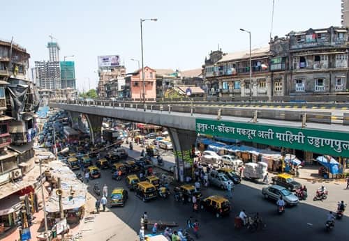
 Mumbai has a handful of road structures that go beyond infrastructure and become part of the city’s urban mythology, and the JJ Flyover is firmly in that category. Connecting South Mumbai to the eastern suburbs across one of the most historically layered parts of the city, this elevated corridor stretches over the Byculla and Mazgaon zones in a sweep that offers commuters one of the more visually striking urban road experiences in any Indian city — the industrial waterfront of the eastern docks on one side, the dense residential fabric of Central Mumbai on the other, and the constant forward momentum of a flyover that simply refuses to let the city’s notorious ground-level congestion slow it down.
Named after Sir Jamsetjee Jejeebhoy — the legendary Parsi philanthropist whose name graces the famous JJ Hospital and JJ School of Art nearby — the flyover has become one of the most important connectors in Mumbai’s east-west and north-south movement patterns. It links the Mohammed Ali Road area and the Byculla zone to the eastern freeway network, providing a fast elevated route that serves commuters traveling between South Mumbai’s business district and the eastern suburban corridor. For residents of Mazgaon, Byculla, Dongri, and the broader central Mumbai residential belt, and for the enormous daily movement of vehicles between the docks, the city center, and the eastern highway network, this flyover is infrastructure whose value is felt in the time it saves every single day.
| Detail | Information |
| Location | JJ Flyover, Byculla-Mazgaon, Central Mumbai, Maharashtra |
| Primary Road | Eastern Freeway / JJ Road (Dr. Babasaheb Ambedkar Road) |
| Nearest Metro Station | Byculla — Mumbai Metro Line 2B |
| Nearest Railway Station | Byculla Railway Station — Approx. 1–2 km |
| Key Roads Connected | Eastern Freeway, JJ Road, P D’Mello Road, Mazgaon Road |
| Distance from CST | Approx. 4–5 km |
| Distance from BKC | Approx. 10–12 km via Eastern Freeway |
| Distance from Thane | Approx. 30–35 km via Eastern Express Highway |
| Governing Authority | BMC, MSRDC, MMRDA |
| Nearby Landmarks | JJ Hospital, JJ School of Art, Byculla Zoo, Mazgaon Docks |
| Structure Type | Elevated Road Flyover / Connector |
| Public Transport Options | Mumbai Metro Line 2B, Central Railway, BEST Bus, App Cabs |
| Best Suited For | South Mumbai to Eastern Freeway corridor traffic |
| Peak Traffic Hours | 8:00 AM – 10:30 AM and 5:30 PM – 9:30 PM |
Directions to JJ Flyover
From CST / South Mumbai: Travel northward from Chhatrapati Shivaji Maharaj Terminus along P D’Mello Road heading toward Mazgaon and Byculla. Continue north toward JJ Road and access the flyover approach from the southern entry ramp. Total distance from CST is approximately 4 to 5 kilometres with a travel time of 15 to 25 minutes.
From Byculla Railway Station: Exit Byculla Station and travel eastward via Dr. Babasaheb Ambedkar Road toward the JJ Flyover approach. The flyover is approximately 1 to 2 kilometres from the station, accessible within 5 to 10 minutes — one of the closest approaches from any rail station to the flyover’s entry point.
From BKC: Travel southward from BKC via the Eastern Freeway heading toward South Mumbai. The JJ Flyover connects to the Eastern Freeway’s southern terminus, making BKC accessible within 10 to 12 kilometres with a travel time of 20 to 35 minutes under moderate conditions.
From Thane: Travel southwestward along the Eastern Express Highway from Thane. Continue past Mulund and Ghatkopar toward the Eastern Freeway and approach the JJ Flyover from the north via the freeway’s southern extension. Total distance from Thane is approximately 30 to 35 kilometres with a travel time of 45 to 65 minutes.
From Navi Mumbai via Vashi: Cross the Vashi Bridge and travel westward along the Sion-Panvel Expressway toward Central Mumbai. Connect to the Eastern Freeway heading southward toward the JJ Flyover zone. Total distance from Navi Mumbai’s commercial center is approximately 20 to 25 kilometres.
Metro and Public Transport Connectivity
Byculla Metro Station on Mumbai Metro Line 2B has added a welcome rail connectivity layer to the JJ Flyover’s neighborhood, connecting the area westward through Dharavi, BKC, and Bandra — effectively linking one of Mumbai’s most historically working-class central zones to the city’s most commercially premium district in a single metro corridor. Byculla Railway Station on the Central Railway’s main line provides suburban rail connectivity northward toward Dadar, Kurla, Thane, and beyond, and southward toward CST. BEST buses operate multiple routes along JJ Road and the connecting arterials, serving the dense residential communities of Byculla, Mazgaon, and Dongri. The flyover’s connection to the Eastern Freeway gives private vehicles and app-based cabs a fast, signal-free option for the South Mumbai to eastern suburbs commute.
Road Connectivity
- Eastern Freeway extends northward from the JJ Flyover toward Ghatkopar and the Eastern Express Highway, providing signal-free connectivity across the eastern suburban corridor.
- JJ Road (Dr. Babasaheb Ambedkar Road) connects southward toward CST and the South Mumbai business district.
- P D’Mello Road runs along the eastern docklands providing access to Mazgaon Docks and the port area.
- Mazgaon Road connects into the Mazgaon residential and industrial zone on the eastern waterfront.
Nearby Areas and Neighbourhoods
JJ Hospital: One of Mumbai’s oldest and largest government hospitals, Sir Jamsetjee Jejeebhoy Hospital is located directly adjacent to the flyover’s approach and is the primary reason this entire zone carries the JJ designation in the city’s urban geography.
Byculla Zoo (Veermata Jijabai Bhosale Udyan): Mumbai’s oldest and most historically significant botanical garden and zoo, Byculla Zoo is a beloved community landmark immediately adjacent to the flyover corridor, drawing school groups and families from across the city.
Mazgaon Docks: The historic shipbuilding and docking complex on the eastern waterfront has defined this part of Mumbai’s industrial character for over a century, and its workforce contributes substantially to the daily traffic that passes through the JJ Flyover junction.
Dongri: One of Mumbai’s most densely populated and culturally distinctive neighborhoods, Dongri is immediately accessible from the JJ Flyover approach and is known for its vibrant street food culture, jewelry markets, and the tight-knit community character of a locality that has retained its identity through Mumbai’s constant urban transformation.
Mohammed Ali Road: The famous street food and commercial corridor of Mohammed Ali Road, celebrated across India for its Ramzan food festival and year-round street food culture, is directly accessible from the JJ Flyover approach and draws visitors from across Mumbai throughout the year.
Frequently Asked Questions (FAQs)
Q1. Where is JJ Flyover located in Mumbai?
It is in the Byculla-Mazgaon zone of Central Mumbai, connecting JJ Road to the Eastern Freeway, approximately 4 to 5 kilometres from CST.
Q2. Which metro station is nearest to JJ Flyover?
Byculla Metro Station on Mumbai Metro Line 2B is the closest, connecting this central Mumbai zone to BKC and Bandra.
Q3. What railway station serves the JJ Flyover area?
Byculla Railway Station on the Central Railway main line is approximately 1 to 2 kilometres from the flyover.
Q4. What is the Eastern Freeway connection from JJ Flyover?
The JJ Flyover connects directly to the Eastern Freeway, providing signal-free road access northward to Ghatkopar and the Eastern Express Highway toward Thane.
Q5. What are the key landmarks near JJ Flyover?
JJ Hospital, Byculla Zoo, Mazgaon Docks, Mohammed Ali Road, and Dongri are the most prominent landmarks near the flyover.