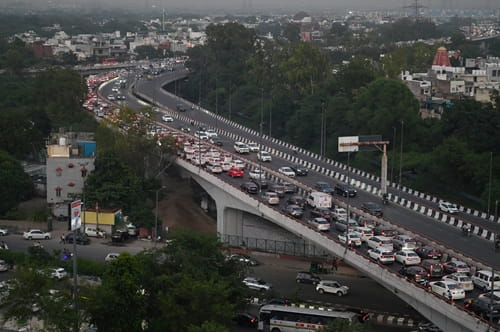
Northwest Delhi carries the working-class industrial energy that has powered much of the capital’s manufacturing economy for decades, and Mangolpuri sits at the heart of this productive zone. One of Delhi’s largest planned industrial and residential localities, Mangolpuri has grown into a densely populated urban belt whose daily traffic demands reflect the complexity of a neighborhood that functions simultaneously as a manufacturing hub, a lower-middle-class residential community, and a transit corridor for commuters moving between outer Northwest Delhi and the city’s commercial centers. The Mangolpuri Flyover spans one of this zone’s most congested junctions along the Rohtak Road and Ring Road connector corridor, providing the elevated through-passage that keeps the primary arterial traffic flowing while the ground-level intersection manages the dense local movement of one of Delhi’s most industrially active western localities.
The flyover’s position within the broader Rohtak Road-Outer Ring Road network gives it a connectivity significance that extends beyond the immediate Mangolpuri residential community. Vehicles traveling between Delhi’s northwestern industrial estates, commuters from Rohini and Mangolpuri’s residential sectors heading toward Central Delhi employment zones, and the freight traffic serving the industrial units of the Mangolpuri and Sultanpuri manufacturing belt all converge at this junction daily. For all of them, the flyover is the structure that converts what would otherwise be an impassable peak-hour gridlock into a manageable daily transit experience.
| Detail | Information |
| Location | Mangolpuri, North-West Delhi |
| Primary Road | Rohtak Road (NH-9) / Ring Road Connector |
| Nearest Metro Station | Mangolpuri — Delhi Metro Green Line |
| Key Roads Connected | Rohtak Road (NH-9), Ring Road Connector, Mangolpuri Road, Sultanpuri Road |
| Distance from Connaught Place | Approx. 16–18 km |
| Distance from Rohini | Approx. 5–6 km |
| Distance from Peeragarhi | Approx. 3–4 km |
| Governing Authority | PWD Delhi, NHAI, DMRC |
| Nearby Landmarks | Mangolpuri Industrial Area, Rohini Sectors, Sultanpuri Colony |
| Structure Type | Elevated Road Overpass / Flyover |
| Public Transport Options | Delhi Metro Green Line, DTC Bus, App Cabs, Auto-Rickshaw |
| Best Suited For | Northwest Delhi Rohtak Road and industrial corridor traffic |
| Peak Traffic Hours | 8:00 AM – 10:30 AM and 5:30 PM – 9:00 PM |
Directions to Mangolpuri Flyover
From Connaught Place: Travel westward from Connaught Place via Patel Road heading toward Patel Nagar and Peeragarhi. Continue along Rohtak Road heading northwestward toward the Mangolpuri zone. Total distance is approximately 16 to 18 kilometres with a travel time of 35 to 55 minutes through the western Delhi arterial network.
From Peeragarhi: Travel northward from Peeragarhi junction along the road connector heading toward Mangolpuri. The flyover is approximately 3 to 4 kilometres from Peeragarhi with a travel time of 10 to 15 minutes — the most direct approach from the nearest major western Delhi intersection.
From Rohini: Travel southwestward from Rohini’s residential sectors via the Rohini-Mangolpuri connector heading toward the Rohtak Road zone. The flyover is approximately 5 to 6 kilometres from Rohini Sector 3 with a travel time of 15 to 25 minutes through the connecting residential road network.
From Nangloi: Travel northward from Nangloi along Rohtak Road heading toward Mangolpuri. The flyover is approximately 4 to 5 kilometres from Nangloi Metro Station with a travel time of 15 to 20 minutes along this important western Delhi highway corridor.
From Bahadurgarh, Haryana: Enter Delhi via Rohtak Road (NH-9) heading southeast from Bahadurgarh. Continue past the Tikri Kalan and Nangloi zones heading toward Mangolpuri. The flyover is approximately 10 to 12 kilometres inside Delhi from the Bahadurgarh border with a travel time of 25 to 40 minutes.
Metro and Public Transport Connectivity
Mangolpuri Metro Station on the Delhi Metro Green Line is the nearest rail access point, connecting this northwestern locality to the Green Line corridor that passes through Inderlok, Ashok Park Main, Punjabi Bagh West, and continues southward toward Brigadier Hoshiyar Singh Station. Interchange connectivity at Inderlok with the Red Line and at Rajouri Garden with the Blue Line gives Mangolpuri residents access to the full Delhi Metro network from this single Green Line corridor. DTC buses operate multiple routes along Rohtak Road and the Mangolpuri connecting roads, serving the enormous working-class residential population of this northwestern belt. Auto-rickshaws and shared tempos provide the primary intra-Mangolpuri movement throughout the day, and app-based cabs are available for longer-distance journeys toward metro stations and city centers.
Road Connectivity
- Rohtak Road (NH-9) extends westward toward Bahadurgarh, Rohtak, and deeper into Haryana.
- Ring Road Connector links the flyover to the Outer Ring Road’s northwestern arc.
- Mangolpuri Road provides access into the industrial estate and residential interior.
- Sultanpuri Road extends northward toward the Sultanpuri residential and light industrial zone.
Nearby Areas and Neighbourhoods
Mangolpuri Industrial Area: One of Delhi’s most important planned industrial estates, Mangolpuri’s manufacturing belt houses garment units, light engineering workshops, food processing establishments, and the kind of small-to-medium industrial operations that have employed several generations of northwest Delhi’s working population.
Sultanpuri: A densely populated residential locality north of the flyover, Sultanpuri is one of Delhi’s larger outer residential zones offering affordable housing for the working and lower-middle-class population of northwest Delhi’s industrial fringe.
Rohini: Delhi’s largest planned residential township, spread across 22 sectors, is directly connected to the Mangolpuri corridor and provides the primary residential counterpart to the industrial character of the immediate flyover zone.
Paschim Vihar: One of West Delhi’s most established and well-maintained planned residential colonies, Paschim Vihar is accessible from the Mangolpuri corridor and offers a more premium residential character within reasonable reach of the flyover’s connectivity.
Tikri Kalan: A densely populated locality near the Delhi-Haryana border, Tikri Kalan is connected to the Mangolpuri flyover via Rohtak Road and represents the westernmost residential fringe of Delhi’s formal urban boundary in this direction.
Frequently Asked Questions (FAQs)
Q1. Where is Mangolpuri Flyover located in Delhi?
It is in Mangolpuri, North-West Delhi, on the Rohtak Road and Ring Road connector, approximately 16 to 18 kilometres from Connaught Place.
Q2. Which metro station is nearest to Mangolpuri Flyover?
Mangolpuri Metro Station on the Delhi Metro Green Line is the closest station, providing connectivity to Inderlok and the broader metro network.
Q3. What industrial areas are near Mangolpuri Flyover?
Mangolpuri Industrial Area is the primary manufacturing zone directly adjacent to the flyover, housing garment, engineering, and food processing units.
Q4. How far is Mangolpuri from Rohini?
Rohini is approximately 5 to 6 kilometres from the flyover, connected via the residential road network of northwest Delhi.
Q5. Is Mangolpuri Flyover on the Rohtak Road highway?
Yes, the flyover is positioned on Rohtak Road (NH-9), the primary highway connecting Delhi to Rohtak, Bahadurgarh, and Haryana’s western districts.