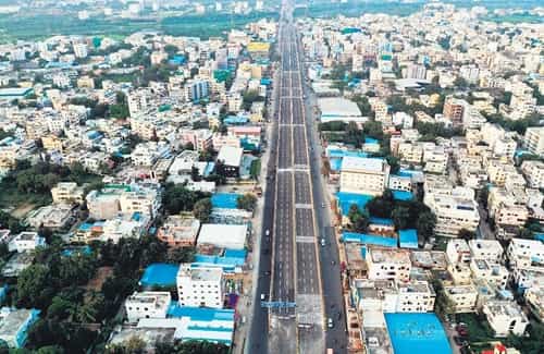
Eastern Hyderabad has been one of the city’s more quietly consequential growth corridors — not as glamorous as HITEC City’s western tech belt, not as historically layered as the old city’s southern zones, but genuinely important as the residential and commercial backbone of the large working and middle-class population that fills the apartments of Uppal, Nagole, LB Nagar, and the broader eastern suburban belt. Nagole sits at the eastern terminus of the Hyderabad Metro Blue Line, at a junction that has become one of the city’s most important eastern transit nodes for the simple reason that it is where the metro ends and the road begins for hundreds of thousands of daily commuters whose journeys extend beyond the rail network’s current reach. The Nagole Flyover spans one of this eastern corridor’s most active junctions, providing the elevated through-passage that manages the convergence of metro feeder traffic, highway vehicles, and the daily residential commuter movement of east Hyderabad’s densely populated residential belt.
The flyover’s position at the intersection of the Nagole and Uppal approach roads with the Hyderabad-Vijayawada National Highway gives it a connectivity significance that extends well beyond the metropolitan boundary. For daily commuters, for inter-city travelers heading eastward toward Vijayawada and the Andhra Pradesh coastal cities, for residents of the large apartment communities of LB Nagar, Nagole, and Vanasthalipuram, and for the logistics operators moving goods along the eastern highway corridor, this flyover is a daily necessity whose smooth functioning has real economic and personal consequences across a very broad catchment of users.
Nagole Flyover Overview
| Detail | Information |
| Location | Nagole, East Hyderabad, Telangana |
| Primary Road | Hyderabad-Vijayawada Highway (NH-65) / Nagole Road |
| Nearest Metro Station | Nagole — Hyderabad Metro Blue Line (Eastern Terminal) |
| Key Roads Connected | NH-65, Nagole Road, Uppal Road, LB Nagar Road |
| Distance from Hyderabad City Centre (Abids) | Approx. 12–15 km |
| Distance from HITEC City | Approx. 25–28 km via Blue Line |
| Distance from Vijayawada | Approx. 270 km via NH-65 |
| Governing Authority | GHMC, HMDA, NHAI, Telangana Roads and Buildings |
| Nearby Landmarks | Nagole Metro Station, LB Nagar Commercial Area, Uppal Stadium |
| Structure Type | Elevated Road Overpass / Flyover |
| Public Transport Options | Hyderabad Metro Blue Line, TSRTC Bus, App Cabs, Auto-Rickshaw |
| Best Suited For | East Hyderabad metro feeder traffic and NH-65 highway corridor |
| Peak Traffic Hours | 8:30 AM – 10:30 AM and 6:00 PM – 9:30 PM |
Directions to Nagole Flyover
From Hyderabad City Centre (Abids): Travel eastward from Abids via the central city arterials heading toward the eastern residential belt. Continue through Malakpet and LB Nagar toward Nagole approximately 12 to 15 kilometres from the city center. Travel time is approximately 30 to 50 minutes through the eastern corridor’s variable traffic conditions.
From Secunderabad: Take the Hyderabad Metro Blue Line from Secunderabad eastward heading toward Nagole. Travel directly to Nagole Metro Station at the line’s eastern terminus. By road, the distance is approximately 15 to 18 kilometres with a travel time of 35 to 55 minutes.
From HITEC City: Take the Hyderabad Metro Blue Line from HITEC City heading eastward through Ameerpet, Secunderabad, and all the way to the Nagole terminus. Total metro travel time is approximately 45 to 55 minutes. By road the distance is approximately 25 to 28 kilometres with considerably longer travel times through cross-city traffic.
From LB Nagar: Travel northward from LB Nagar along the LB Nagar Road heading toward Nagole junction. The flyover is approximately 3 to 4 kilometres from LB Nagar’s central commercial zone with a travel time of 10 to 15 minutes — one of the most direct approaches from any adjacent locality.
From Vijayawada via NH-65: Travel westward from Vijayawada along NH-65 heading toward Hyderabad. Continue through Nalgonda district and approach Nagole from the eastern highway direction approximately 270 kilometres from Vijayawada. Nagole Flyover is encountered as the first major elevated junction upon entering Hyderabad’s metropolitan boundary from this eastern highway approach.
Metro and Public Transport Connectivity
Nagole Metro Station at the eastern terminus of the Hyderabad Metro Blue Line is the single most important public transport feature of this flyover’s zone, making Nagole one of the most transit-significant eastern Hyderabad junctions in the entire metropolitan area. The Blue Line connects Nagole westward through LB Nagar, Uppal, Secunderabad East, Ameerpet, HITEC City, and all the way to Raidurgam — covering the full east-west span of Hyderabad’s urban agglomeration in a single uninterrupted rail corridor. As the metro’s eastern terminus, Nagole Station functions as a park-and-ride hub for commuters from the broader eastern suburban belt who drive to the metro and continue by rail toward the western employment corridor. TSRTC buses serve multiple routes through the Nagole and Uppal corridor connecting the flyover area to Hyderabad Bus Station, Secunderabad, LB Nagar, and further eastern destinations. Auto-rickshaws are abundantly available at the metro station exits throughout the day.
Road Connectivity
- NH-65 runs east to west as the primary national highway connecting Hyderabad to Vijayawada and the Andhra Pradesh coastal network.
- Nagole Road provides the primary local arterial access into the Nagole residential and commercial zone.
- Uppal Road extends northward toward the Uppal residential and Rajiv Gandhi International Cricket Stadium zone.
- LB Nagar Road connects southward toward the LB Nagar commercial hub and the southeastern suburban residential belt.
Nearby Areas and Neighbourhoods
LB Nagar: One of east Hyderabad’s most important commercial and residential hubs, LB Nagar is directly connected to Nagole via the southern road network and serves as the primary commercial destination for the large residential population of the southeastern suburban belt.
Uppal: A growing residential and industrial locality north of Nagole, Uppal hosts the Rajiv Gandhi International Cricket Stadium and has seen substantial residential development driven by its metro connectivity and relatively affordable pricing within the eastern suburban market.
Vanasthalipuram: A large and densely populated residential locality southeast of Nagole, Vanasthalipuram offers affordable apartment housing for the working and lower-middle-class population of eastern Hyderabad and is one of the primary feeder zones for the Nagole Metro terminus’s daily passenger volumes.
Boduppal: An emerging residential locality east of the flyover along the NH-65 corridor, Boduppal has attracted significant mid-segment apartment development from buyers seeking metro-proximate addresses at competitive prices beyond the established eastern localities.
Peerzadiguda: A rapidly developing residential zone further east of Nagole along the Vijayawada highway corridor, Peerzadiguda’s growing apartment communities depend on the Nagole junction’s road and metro infrastructure for their daily connectivity to Hyderabad’s employment and commercial centers.
Frequently Asked Questions (FAQs)
Q1. Where is Nagole Flyover located in Hyderabad?
A: It is in Nagole, East Hyderabad, on NH-65 at the junction with Nagole Road and Uppal Road, approximately 12 to 15 kilometres from Abids city centre.
Q2. Which metro station is at Nagole Flyover?
A: Nagole Metro Station is the eastern terminus of the Hyderabad Metro Blue Line, directly at the flyover and connecting the eastern belt to HITEC City and Raidurgam.
Q3. How far is Nagole from HITEC City?
A: HITEC City is approximately 25 to 28 kilometres from Nagole by road, though the Blue Line metro covers this journey in approximately 45 to 55 minutes more comfortably.
Q4. What residential areas are near Nagole Flyover?
A: LB Nagar, Uppal, Vanasthalipuram, and Boduppal are the most prominent residential localities near the flyover.
Q5. Is Nagole on the Hyderabad-Vijayawada highway?
A: Yes, NH-65 connecting Hyderabad to Vijayawada passes directly through Nagole, making the flyover the primary elevated gateway into Hyderabad from the eastern highway approach.