 By Ketan Kumar
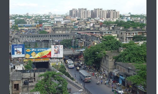
 Ultadanga occupies a genuinely strategic position in Kolkata’s urban geography — sitting at the junction of the city’s northern residential expansion, the eastern suburban highway network, and the approach roads to the airport, it handles a traffic mix that would challenge any road infrastructure. The locality’s name carries an old Kolkata familiarity — generations of residents have used Ultadanga as a navigation reference point in the same way that long-established cities accumulate these oral landmarks that persist through decades of urban change. The Ultadanga Flyover spans one of the junction’s most demanding traffic nodes, providing the elevated through-corridor that allows the primary VIP Road and EM Bypass traffic to maintain momentum while the ground-level intersection manages the local movement of North Kolkata’s dense residential population below.
The flyover’s position at the northern end of the Maa Flyover corridor and its connection to VIP Road heading toward the airport makes it one of the most functionally important elevated structures in Kolkata’s infrastructure network. For residents of Ultadanga, Shyambazar, and the broader North Kolkata residential belt who commute eastward toward Salt Lake and the airport zone, and for airport travelers whose road journey begins or ends at this junction, the Ultadanga Flyover is the structure that defines the quality of that daily transit experience in measurable, practical terms.
Overview Table
| Detail | Information |
| Location | Ultadanga, North Kolkata, West Bengal |
| Primary Road | VIP Road / EM Bypass Northern End |
| Nearest Metro Station | Ultadanga — Kolkata Metro Yellow Line (Line 6) |
| Nearest Railway Station | Sealdah Railway Station — Approx. 6–8 km |
| Key Roads Connected | VIP Road, EM Bypass, Baguiati Road, Kankurgachi Road |
| Distance from Esplanade | Approx. 7–9 km |
| Distance from Salt Lake | Approx. 5–6 km |
| Distance from Airport | Approx. 14–16 km via VIP Road |
| Governing Authority | KMC, KMDA, PWD West Bengal |
| Nearby Landmarks | Ultadanga More, Baguiati Market, Kankurgachi Industrial Area |
| Structure Type | Elevated Road Overpass / Flyover |
| Public Transport Options | Kolkata Metro Yellow Line, WBTC Bus, App Cabs, Auto-Rickshaw |
| Best Suited For | North Kolkata VIP Road and EM Bypass northern corridor traffic |
| Peak Traffic Hours | 8:00 AM – 10:30 AM and 5:30 PM – 9:00 PM |
Directions to Ultadanga Flyover
From Esplanade / City Centre: Travel northward from Esplanade via APC Road or MG Road heading toward North Kolkata. Continue through Shyambazar and approach Ultadanga approximately 7 to 9 kilometres from the city center. Travel time is approximately 25 to 40 minutes through the characteristically dense North Kolkata road network.
From Salt Lake: Travel westward from Salt Lake City via the EM Bypass connector heading toward Ultadanga. The flyover is approximately 5 to 6 kilometres from Salt Lake’s Sector V area with a travel time of 15 to 25 minutes along this important east-west connector.
From Netaji Subhas Chandra Bose International Airport: Exit the airport via VIP Road heading southward toward Kolkata. Continue along VIP Road through Baguiati and Keshtopur approaching Ultadanga approximately 14 to 16 kilometres from the airport. Travel time is approximately 30 to 45 minutes depending on VIP Road’s variable traffic conditions through the northeastern suburban corridor.
From Sealdah Railway Station: Travel northward from Sealdah via the connecting arterials heading toward North Kolkata. Continue through the Phoolbagan zone toward Ultadanga approximately 6 to 8 kilometres from the station with a travel time of 20 to 35 minutes.
From Shyambazar: Travel eastward from Shyambazar’s famous five-point junction along the APC Road heading toward Ultadanga. The flyover is approximately 2 to 3 kilometres from Shyambazar with a travel time of 10 to 20 minutes — one of the shortest approaches from any immediately adjacent major junction.
Metro and Public Transport Connectivity
Ultadanga Metro Station on Kolkata Metro Line 6 — the Orange Line or the East-West Metro — provides rail connectivity at this northern junction, connecting the area eastward toward the Howrah Maidan corridor and westward through Salt Lake and onward. The East-West Metro’s cross-city alignment gives Ultadanga station a connectivity significance that complements the north-south Yellow Line’s coverage of this broader zone. WBTC buses operate several routes along VIP Road and the EM Bypass through Ultadanga, connecting the flyover area to Esplanade, Salt Lake, the airport, and the broader Kolkata bus network with the frequency that North Kolkata’s dense residential population demands. Yellow taxis and auto-rickshaws serve the junction’s local connectivity needs, and app-based cabs have seen strong adoption in this increasingly commercially active zone.
Road Connectivity
- VIP Road runs northward toward the airport and the Barasat corridor, serving as the primary northeastern highway approach to the airport from the city.
- EM Bypass connects southward along Kolkata’s eastern circumferential highway toward Park Circus, Mukundapur, and the southern suburbs.
- Baguiati Road extends northeastward toward the rapidly developing Baguiati and Keshtopur residential zones.
- Kankurgachi Road connects southwestward toward Kankurgachi’s industrial and residential belt.
Nearby Areas and Neighbourhoods
Kankurgachi: An industrial and residential locality immediately southwest of the flyover, Kankurgachi houses manufacturing establishments and working-class residential communities that contribute a significant proportion of the daily commercial and commuter traffic at the Ultadanga junction.
Baguiati: A rapidly developing northeastern residential and commercial locality along VIP Road, Baguiati has attracted substantial apartment development in recent years as families seek addresses within the airport road corridor at prices more accessible than Salt Lake’s established zones.
Salt Lake City: Kolkata’s most prestigious planned township is directly connected to Ultadanga via the EM Bypass and represents the primary eastern commuter destination for the large professional and government employee population of North Kolkata’s residential zones.
New Town Rajarhat: The ambitious new township northeast of Ultadanga along the VIP Road and airport corridor is directly accessible from the flyover zone and represents the most significant urban development investment in this northeastern quadrant of the Kolkata metropolitan area.
Shyambazar: One of Kolkata’s most historically and culturally embedded North Kolkata localities, Shyambazar is directly connected to Ultadanga and is famous for its five-point junction, the Shyambazar Netaji Subhash statue, and its vibrant Bengali cultural and commercial character.
Frequently Asked Questions (FAQs)
Q1. Where is Ultadanga Flyover located in West Bengal?
It is in Ultadanga, North Kolkata, at the junction of VIP Road and the northern end of the EM Bypass, approximately 7 to 9 kilometres from Esplanade city centre.
Q2. Which metro station serves Ultadanga Flyover?
Ultadanga Metro Station on Kolkata Metro Line 6 (East-West Metro) provides rail connectivity to this northern junction.
Q3. How far is Ultadanga from Kolkata Airport?
The airport is approximately 14 to 16 kilometres from Ultadanga Flyover via VIP Road, with a travel time of 30 to 45 minutes.
Q4. What residential areas are near Ultadanga Flyover?
Kankurgachi, Baguiati, and Shyambazar are the most prominent residential localities near the flyover, with Salt Lake and New Town accessible via the EM Bypass and VIP Road corridors.
Q5. Is Ultadanga on the VIP Road airport corridor?
Yes, VIP Road passing through Ultadanga is the primary road connecting central Kolkata to the airport via the northeastern suburban corridor.