North Delhi has a commercial energy that is entirely its own — wholesale markets, agricultural mandis, dense residential colonies, and the kind of working-class urban vitality that the city’s more polished southern neighborhoods rarely match for sheer productive intensity. Azadpur sits at the center of this energy, home to one of Asia’s largest fruit and vegetable wholesale markets and a junction that handles the extraordinary daily convergence of agricultural trucks, mandi traders, residential commuters, and the through-traffic of Delhi’s northern arterial road network. The Azadpur Flyover spans this demanding junction, providing the elevated corridor that allows primary road traffic to continue moving while the enormous commercial activity of the mandi and its surrounding markets proceeds below.
The flyover’s significance extends well beyond ordinary traffic management. Azadpur Mandi’s operations depend on the efficient movement of thousands of trucks, tempos, and commercial vehicles that arrive daily from across Haryana, Punjab, Himachal Pradesh, and Uttar Pradesh carrying produce that feeds a significant proportion of Delhi’s population. The road infrastructure surrounding the mandi — and the flyover at its heart — directly affects how efficiently that supply chain functions. For the traders, commission agents, truck drivers, and daily wage workers whose livelihoods depend on Azadpur’s wholesale economy, the flyover is as much a commercial asset as it is a transport structure.
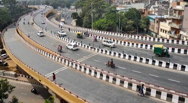
Azadpur Flyover Overview
| Detail | Information |
| Location | Azadpur, North Delhi |
| Primary Road | GT Karnal Road (NH-44) / Outer Ring Road |
| Nearest Metro Station | Azadpur — Delhi Metro Yellow and Pink Lines |
| Key Roads Connected | GT Karnal Road (NH-44), Outer Ring Road, Rani Bagh Road, Shalimar Bagh Road |
| Distance from Connaught Place | Approx. 12–14 km |
| Distance from Mukarba Chowk | Approx. 3–4 km |
| Distance from Rohini | Approx. 5–6 km |
| Governing Authority | PWD Delhi, NHAI, DMRC |
| Nearby Landmarks | Azadpur Mandi, Model Town, Shalimar Bagh, Rani Bagh |
| Structure Type | Elevated Road Overpass / Flyover |
| Public Transport Options | Delhi Metro Yellow and Pink Lines, DTC Bus, App Cabs, Auto-Rickshaw |
| Best Suited For | North Delhi GT Karnal Road and mandi commercial corridor traffic |
| Peak Traffic Hours | 6:00 AM – 10:00 AM and 5:00 PM – 9:00 PM |
Directions to Azadpur Flyover
From Connaught Place: Travel northward from Connaught Place via Outer Ring Road or Pusa Road heading toward North Delhi. Continue along the Ring Road through Wazirpur and approach Azadpur approximately 12 to 14 kilometres from the city center. Travel time is approximately 30 to 50 minutes depending on North Delhi’s notoriously variable traffic conditions through the afternoon peak.
From Mukarba Chowk: Travel southward from Mukarba Chowk along GT Karnal Road heading toward the city. Azadpur Flyover is approximately 3 to 4 kilometres ahead with a travel time of 10 to 15 minutes. This is the most direct southbound approach from the northern highway entry point into Delhi.
From Rohini: Travel eastward from Rohini’s sector road network toward the Outer Ring Road. Continue southward along the Ring Road connecting to GT Karnal Road at Azadpur. Total distance from Rohini Sector 3 area is approximately 5 to 6 kilometres with a travel time of 15 to 25 minutes.
From Model Town: Travel northward from Model Town via the Model Town-Azadpur Road heading toward the mandi zone. The flyover is approximately 2 to 3 kilometres from Model Town’s main market, making this one of the shortest direct approaches from any immediately adjacent locality.
From Haryana via GT Karnal Road (NH-44): Enter Delhi from Haryana via NH-44 heading southward through Singhu Border. Continue along GT Karnal Road into North Delhi. Azadpur Flyover is encountered approximately 8 to 10 kilometres inside the Delhi boundary, serving as the primary elevated structure on this major northern highway entry point.
Metro and Public Transport Connectivity
Azadpur Metro Station is one of Delhi Metro’s most strategically placed interchange stations, sitting at the junction of the Yellow Line and the Pink Line. The Yellow Line connects Azadpur southward to Civil Lines, Kashmere Gate, Chandni Chowk, Connaught Place, and all the way to HUDA City Centre in Gurugram. The Pink Line connects eastward toward Welcome, Anand Vihar, and IP Extension, and westward toward Shakurpur and Majlis Park — giving Azadpur commuters access to a remarkably broad cross-section of Delhi’s metro network from a single interchange station. DTC buses operate multiple high-frequency routes through GT Karnal Road and the Outer Ring Road near Azadpur, serving the enormous commercial and residential population of North Delhi. Auto-rickshaws operate extensively around the mandi and metro station area throughout the day.
Road Connectivity
- GT Karnal Road (NH-44) runs north to south as Delhi’s primary northern highway entry connecting the city to Panipat, Ambala, and Punjab.
- Outer Ring Road provides circumferential connectivity linking Azadpur to Wazirpur, Shalimar Bagh, and the northern Ring Road belt.
- Rani Bagh Road connects westward into the Rani Bagh and Pitampura residential zones.
- Shalimar Bagh Road extends northwestward into the Shalimar Bagh planned residential colony.
Nearby Areas and Neighbourhoods
Azadpur Mandi: Asia’s largest fruit and vegetable wholesale market is the defining commercial landmark of this junction, generating the enormous daily vehicle movement that the flyover was primarily designed to manage. The mandi’s operations begin in the early hours of the morning, giving this junction its unusually early peak traffic pattern.
Model Town: One of North Delhi’s most established and well-regarded residential localities, Model Town offers premium independent houses, excellent schools, strong community infrastructure, and a local market that serves the area’s solidly middle and upper-middle-class residential population.
Shalimar Bagh: A large planned residential colony immediately northwest of Azadpur, Shalimar Bagh is popular among Delhi government employees and professionals seeking relatively affordable housing within a planned colony environment with good civic amenities.
Rani Bagh: An established residential locality west of the flyover, Rani Bagh offers mid-segment housing and strong local commercial infrastructure within comfortable metro and bus connectivity of the Azadpur interchange.
Wazirpur Industrial Area: The significant industrial zone south of Azadpur along the Outer Ring Road contributes heavy vehicle traffic to the flyover corridor and employs a large workforce that uses the mandi area’s transit infrastructure for daily commuting.
Frequently Asked Questions (FAQs)
Q1. Where is Azadpur Flyover located in Delhi?
A: It is in Azadpur, North Delhi, on GT Karnal Road near the Azadpur Mandi, approximately 12 to 14 kilometres from Connaught Place.
Q2. Which metro lines serve Azadpur Flyover?
A: Azadpur Metro Station is an interchange between the Delhi Metro Yellow Line and Pink Line, providing access to a broad cross-section of the city’s network.
Q3. What is Azadpur Mandi and why is it significant?
A: Azadpur Mandi is one of Asia’s largest wholesale fruit and vegetable markets and is the primary commercial driver of traffic at the flyover junction.
Q4. What residential areas are near Azadpur Flyover?
A: Model Town, Shalimar Bagh, and Rani Bagh are the most prominent residential localities near the flyover.
Q5. Is Azadpur on the GT Karnal Road highway corridor?
A: Yes, the flyover is positioned directly on NH-44 (GT Karnal Road), Delhi’s primary northern highway entry from Haryana and Punjab.