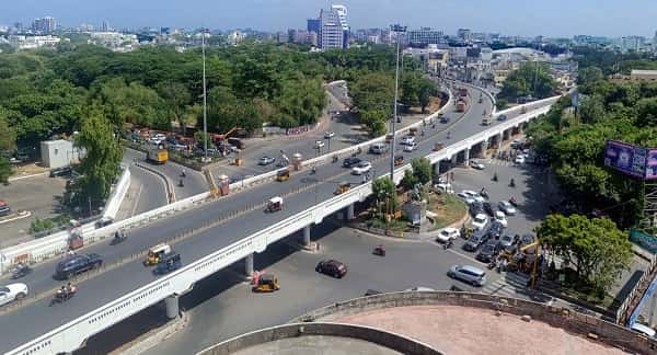
Anna Flyover is not just one of Chennai’s most important elevated road structures — it is a piece of the city’s civic identity. Named in honour of C.N. Annadurai, the beloved first Chief Minister of Tamil Nadu and the founding father of Dravidian politics, the flyover carries both the physical weight of Chennai’s commuter traffic and the symbolic weight of a name that every Tamil Nadu resident recognizes with deep respect. Located in the heart of the city’s administrative and residential core, it spans one of Chennai’s busiest junctions and has been a defining element of how central Chennai moves for decades.
The flyover’s location near Anna Salai — the city’s principal commercial boulevard, named for the same leader — places it within the epicenter of Chennai’s governmental, commercial, and cultural geography. The surrounding area encompasses the state secretariat complex, premium residential localities, prestigious educational institutions, and the dense commercial activity that has always characterized this part of the city. For residents of Teynampet, Nandanam, Saidapet, and the broader central Chennai belt, Anna Flyover is not a landmark they look up at — it is something they drive across without thinking, which is the surest measure of a piece of infrastructure that has earned its place in urban life.
Anna Flyover, Chennai Overview
| Detail | Information |
| Location | Anna Flyover, Anna Salai, Central Chennai, Tamil Nadu |
| Primary Road | Anna Salai (Mount Road) / Rajaji Salai Connector |
| Nearest Metro Station | Teynampet — Chennai Metro Blue Line |
| Key Roads Connected | Anna Salai, Rajaji Salai, Nandanam Road, Saidapet Road |
| Distance from Central Railway Station | Approx. 4–5 km |
| Distance from Chennai Airport | Approx. 10–12 km via Anna Salai |
| Distance from Marina Beach | Approx. 3–4 km |
| Governing Authority | Greater Chennai Corporation (GCC), Tamil Nadu PWD |
| Nearby Landmarks | Tamil Nadu Secretariat, AIADMK HQ, DMS Junction |
| Structure Type | Elevated Road Overpass / Flyover |
| Public Transport Options | Chennai Metro Blue Line, MTC Bus, App Cabs, Auto-Rickshaw |
| Best Suited For | Central Chennai Anna Salai corridor through traffic |
| Peak Traffic Hours | 8:30 AM – 10:30 AM and 5:00 PM – 9:00 PM |
Directions to Anna Flyover
From Central Railway Station / George Town: Travel southward along Rajaji Salai from Park Town. Continue through the Chintadripet connector toward Anna Salai. Approach Anna Flyover from the northern end approximately 4 to 5 kilometres from Central Station with a travel time of 15 to 25 minutes.
From Chennai Airport: Travel northward along Anna Salai from the airport heading toward the city center. Continue through Guindy and Saidapet toward the flyover. Total distance from the airport is approximately 10 to 12 kilometres with a travel time of 25 to 40 minutes along this consistently busy arterial road.
From Adyar / South Chennai: Travel northward along Anna Salai from Adyar junction through Saidapet and Nandanam. Anna Flyover is accessible approximately 6 to 8 kilometres from Adyar with a travel time of 20 to 35 minutes.
From T. Nagar: Travel eastward from T. Nagar’s commercial core via Panagal Park Road toward Anna Salai. Merge onto Anna Salai heading north and reach Anna Flyover within 3 to 4 kilometres, taking approximately 10 to 20 minutes.
From Tambaram: Travel northward along GST Road from Tambaram and merge onto Anna Salai via the Guindy connector. Continue northward approximately 15 to 18 kilometres from Tambaram to reach Anna Flyover, with a travel time of 35 to 55 minutes.
Metro and Public Transport Connectivity
Teynampet Metro Station on the Chennai Metro Blue Line is the closest rail-based public transport access point to Anna Flyover, placing the flyover within the metro network’s reach and connecting it to Chennai Central, Chennai Airport, and the broader Blue Line corridor. The Blue Line passes through several key stations including LIC, Nandanam, Saidapet, and continues southward to the airport, providing a genuinely useful alternative to Anna Salai’s often congested road surface for commuters. MTC bus services operate some of their highest-frequency routes along Anna Salai through the flyover zone, connecting it to Central Station, T. Nagar, Adyar, Tambaram, and the broader Chennai bus network. Auto-rickshaws and app-based cabs are readily available throughout the central Chennai zone around the flyover at all operating hours.
Road Connectivity
- Anna Salai (Mount Road) runs north to south as Chennai’s principal commercial boulevard connecting the city center to Guindy and beyond.
- Rajaji Salai connects northward toward George Town, the High Court, and Chennai’s port and administrative complex.
- Nandanam Road extends westward into Nandanam’s residential and commercial zone.
- Saidapet Road provides southward access into the Saidapet residential and commercial corridor.
Nearby Areas and Neighbourhoods
Tamil Nadu Secretariat: The state government’s primary administrative complex is located in the immediate vicinity of Anna Flyover, making the junction one of the most politically and administratively significant road nodes in all of Tamil Nadu. Government officials, journalists, and citizens visiting the secretariat pass through this flyover daily.
Teynampet: One of central Chennai’s most premium residential localities, Teynampet offers upscale apartments, quiet residential streets, proximity to the consulate district, and excellent metro access that has made it one of the most sought-after central Chennai addresses.
Nandanam: A well-established and moderately upscale residential and commercial locality immediately adjacent to the flyover corridor, Nandanam is known for its residential colonies, local market, and the DMS junction commercial hub.
Saidapet: A busy and densely populated locality south of the flyover, Saidapet serves as a commercial and transit junction connecting Anna Salai to the Saidapet railway station and the roads leading toward Velachery and Guindy.
DMS Junction: One of Anna Salai’s most recognizable commercial nodes, the Directorate of Medical Services junction area houses banks, commercial establishments, and government offices that generate significant daily footfall around the flyover’s southern approaches.
Frequently Asked Questions (FAQs)
Q1. Where is Anna Flyover located in Chennai?
A: Anna Flyover is on Anna Salai in central Chennai, approximately 4 to 5 kilometres from Chennai Central Railway Station.
Q2. Which metro station is closest to Anna Flyover?
A: Teynampet Metro Station on the Chennai Metro Blue Line is the nearest station to Anna Flyover.
Q3. How far is Anna Flyover from Chennai Airport?
A: The flyover is approximately 10 to 12 kilometres from Chennai International Airport via Anna Salai.
Q4. What government buildings are near Anna Flyover?
A: The Tamil Nadu State Secretariat complex is the most prominent government landmark located near Anna Flyover.
Q5. What is the best way to travel from T. Nagar to Anna Flyover?
A: Travel eastward via Panagal Park Road toward Anna Salai and head north approximately 3 to 4 kilometres, taking 10 to 20 minutes by road.