 By Ketan Kumar
 Old Hyderabad’s road infrastructure faces a challenge that is both ancient and modern — streets and junctions originally designed for the pace of a Nizam-era city must now accommodate the vehicle volumes of a twenty-first century metropolitan population whose mobility demands have multiplied beyond anything the original urban planners could have anticipated. Dabeerpura sits within this historically layered part of the city, at a junction in the dense southern fabric between Charminar and the Nalgonda Cross Roads corridor where the traffic of the old city’s residential communities, wholesale markets, and daily commercial operations converges with a complexity that only an elevated bypass can meaningfully address. The Dabeerpura Flyover provides exactly that — an elevated through-passage that allows the primary corridor movement to continue above the extraordinary ground-level activity of one of Hyderabad’s most historically and commercially significant southern zones.
The name Dabeerpura itself carries the layered history of this part of the city — a locality whose identity was shaped by the Asaf Jahi period and whose commercial and residential character has been continuously dense and continuously active through every subsequent era of Hyderabad’s remarkable urban history. For the daily commuters navigating between the old city and the southern residential belt, for the wholesale traders whose businesses depend on efficient vehicle movement through this corridor, and for the families who have lived in this zone across generations, the flyover is the modern infrastructure response to an ancient urban challenge.
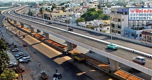
Dabeerpura Flyover Overview
| Detail | Information |
| Location | Dabeerpura, South-Central Hyderabad, Telangana |
| Primary Road | Dabeerpura Road / Nalgonda Cross Roads Connector |
| Nearest Metro Station | MG Bus Station — Hyderabad Metro Blue Line |
| Key Roads Connected | Dabeerpura Road, Nalgonda Road, Charminar Road, Shalibanda Road |
| Distance from Charminar | Approx. 2–3 km |
| Distance from Hyderabad City Centre (Abids) | Approx. 5–6 km |
| Distance from MGBS | Approx. 3–4 km |
| Governing Authority | GHMC, HMDA, Telangana Roads and Buildings |
| Nearby Landmarks | Dabeerpura Market, Nalgonda Cross Roads, Shalibanda Wholesale Zone |
| Structure Type | Elevated Road Overpass / Flyover |
| Public Transport Options | Hyderabad Metro Blue Line, TSRTC Bus, App Cabs, Auto-Rickshaw |
| Best Suited For | Old Hyderabad south-central corridor and Charminar-Nalgonda traffic |
| Peak Traffic Hours | 9:00 AM – 11:30 AM and 5:30 PM – 9:00 PM |
Directions to Dabeerpura Flyover
From Charminar: Travel southward from Charminar along the southern old city arterials heading toward Dabeerpura. The flyover is approximately 2 to 3 kilometres from the iconic Charminar monument — one of Hyderabad’s most immediate major flyover approaches from any heritage landmark — with a travel time of 10 to 20 minutes through the dense old city traffic.
From MGBS (Mahatma Gandhi Bus Station): Travel southward from MGBS along the connecting roads heading toward the Dabeerpura and Nalgonda Cross Roads zone. The flyover is approximately 3 to 4 kilometres from MGBS with a travel time of 15 to 25 minutes.
From Abids / City Centre: Travel southward from Abids via Nampally and the connecting south-city arterials heading toward the Charminar zone. Continue southward toward Dabeerpura approximately 5 to 6 kilometres from Abids with a travel time of 20 to 35 minutes through central Hyderabad’s dense commercial corridor.
From Nalgonda Cross Roads: Travel northward from Nalgonda Cross Roads along Nalgonda Road heading toward the Dabeerpura junction. The flyover is approximately 2 to 3 kilometres from the Nalgonda Cross Roads node with a travel time of 10 to 15 minutes — the most direct southern approach from this important junction.
From Secunderabad: Travel southward through the city via the MGBS connector and continue southward through the old city road network toward Dabeerpura. Total distance from Secunderabad is approximately 10 to 12 kilometres with a travel time of 30 to 45 minutes.
Metro and Public Transport Connectivity
The nearest Hyderabad Metro Blue Line access at MGBS connects the Dabeerpura corridor to the full Blue Line spanning from Raidurgam and HITEC City in the west to Nagole in the east. While a dedicated Dabeerpura station may not sit immediately at the flyover, the MGBS metro access within a short road distance provides meaningful rail connectivity for this dense old city zone. TSRTC operates very high-frequency bus services through the Dabeerpura and Charminar zones — some of the busiest bus routes in all of Hyderabad pass through this corridor given the enormous daily passenger movement between the old city and the broader metropolitan network. Auto-rickshaws are the dominant short-trip transport mode in this densely built old city zone where street widths limit larger vehicle penetration.
Road Connectivity
- Dabeerpura Road runs through the locality’s primary commercial corridor connecting the flyover to the Charminar zone northward.
- Nalgonda Road extends southward connecting toward the Nalgonda Cross Roads and the broader southern highway approach.
- Shalibanda Road provides eastward access toward the Shalibanda wholesale commercial belt.
- Charminar Road connects northward directly to Hyderabad’s most iconic heritage monument and its surrounding commercial district.
Nearby Areas and Neighbourhoods
Shalibanda: One of Hyderabad’s most important wholesale commercial zones immediately east of the flyover, Shalibanda’s markets generate the substantial commercial vehicle traffic that makes this corridor particularly busy during morning market hours.
Nalgonda Cross Roads: The important southern junction connecting the Dabeerpura corridor to the Nalgonda highway and the southeastern residential and commercial belt represents the primary southern connectivity anchor for this flyover zone.
Hasan Nagar and Yakutpura: Dense residential localities within the old city’s southern fabric that depend on the Dabeerpura corridor for their daily connectivity to Hyderabad’s commercial, institutional, and transportation hubs.
Mir Alam Tank Bund: The historic Mir Alam water tank and its surrounding green zone lies within the broader southern Hyderabad belt accessible from the Dabeerpura corridor, providing a natural heritage landmark within an otherwise entirely urban environment.
Falaknuma: The historic Falaknuma Palace zone further south is connected to the Dabeerpura corridor via the southern old city road network, with the flyover serving as a transition point between the old city’s dense northern fabric and its more spacious southern heritage zones.
Frequently Asked Questions (FAQs)
Q1. Where is Dabeerpura Flyover located in Hyderabad?
A: It is in Dabeerpura, South-Central Hyderabad, approximately 2 to 3 kilometres from Charminar on the Dabeerpura Road and Nalgonda Cross Roads corridor.
Q2. Which metro station is nearest to Dabeerpura Flyover?
A: MGBS Metro Station on the Hyderabad Metro Blue Line is the nearest significant rail access point, approximately 3 to 4 kilometres from the flyover.
Q3. How far is Dabeerpura from Charminar?
A: Charminar is approximately 2 to 3 kilometres from Dabeerpura Flyover, making it one of Hyderabad’s closest major flyovers to this iconic heritage monument.
Q4. What wholesale markets are near Dabeerpura Flyover?
A: The Shalibanda wholesale commercial zone is the most prominent market area, directly east of the Dabeerpura flyover corridor.
Q5. What residential areas are near Dabeerpura Flyover?
A: Hasan Nagar, Yakutpura, and the surrounding old city southern residential localities are the most prominent communities near the flyover.