 By Ketan Kumar
 South Bengaluru has a rhythm that residents know well — the morning rush toward Hosur Road, the evening crawl back through Bannerghatta Road, and the constant negotiation of space at junctions that were designed for a fraction of the traffic they now carry. Dairy Circle sits right in the middle of this daily choreography, and the flyover that spans it has become one of the most relied-upon pieces of road infrastructure in the city’s southern corridor. The junction takes its name from the Karnataka Milk Federation dairy that was historically located here — a piece of institutional memory now surrounded by apartments, tech park feeder roads, and the relentless forward march of urban Bengaluru.
The Dairy Circle Flyover serves as a critical connector between Bannerghatta Road and the roads leading toward Jayanagar, JP Nagar, and the Outer Ring Road’s southern arc. For the enormous population of IT professionals, students, families, and commercial operators who live and work in South Bengaluru’s most densely settled localities, this flyover is part of the daily commute in a way that makes its presence felt — and its occasional maintenance closures acutely missed. Understanding its directions, connectivity, and surrounding areas helps anyone navigating this part of the city do so with considerably more confidence.
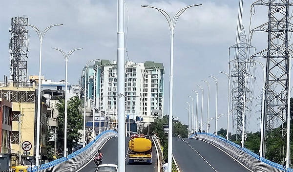
Dairy Circle Flyover, Bengaluru Overview Table
| Detail | Information |
| Location | Dairy Circle, Bannerghatta Road, South Bengaluru, Karnataka |
| Primary Road | Bannerghatta Road / Dairy Circle Junction |
| Nearest Metro Station | Bannerghatta Road — Namma Metro Green Line (Phase 2) |
| Key Roads Connected | Bannerghatta Road, Hosur Road connector, Jayanagar Road, JP Nagar Road |
| Distance from City Centre | Approx. 8–10 km from MG Road |
| Distance from Electronic City | Approx. 12–14 km via Hosur Road |
| Governing Authority | BBMP, BDA |
| Nearby Landmarks | Jayanagar Shopping Complex, Apollo Hospital, Adarsha Palm Retreat |
| Structure Type | Elevated Road Overpass / Flyover |
| Public Transport Options | Namma Metro, BMTC Bus, App Cabs, Auto-Rickshaw |
| Best Suited For | South Bengaluru Bannerghatta Road corridor traffic |
| Peak Traffic Hours | 8:30 AM – 10:30 AM and 5:30 PM – 9:00 PM |
Directions to Dairy Circle Flyover
From MG Road / City Centre: Take Hosur Road southward from Richmond Circle or travel via Lalbagh connecting to Bannerghatta Road. Continue south through Jayanagar and approach Dairy Circle approximately 8 to 10 kilometres from the city center. Travel time is approximately 25 to 40 minutes depending on traffic conditions.
From Electronic City: Travel northward along Hosur Road from Electronic City and connect to Bannerghatta Road via the Bommanahalli junction. Continue northwest toward Dairy Circle. The journey covers approximately 12 to 14 kilometres with a travel time of 25 to 40 minutes.
From Whitefield: Take the Outer Ring Road westward through Marathahalli and Silk Board. From Silk Board, connect to Hosur Road and continue northwest toward Bannerghatta Road junction at Dairy Circle. Total distance is approximately 22 to 25 kilometres.
From Koramangala: Travel southward from Koramangala via the Koramangala-Sarjapur Road connector and approach Dairy Circle from the eastern side. This is a short 5 to 7 kilometre journey taking approximately 15 to 25 minutes.
From Hebbal / Airport: Travel southward along NH-44 through the city center. Connect to Bannerghatta Road via Lalbagh or Richmond Circle and continue southward to Dairy Circle. Total distance from Hebbal is approximately 20 to 25 kilometres.
Metro and Public Transport Connectivity
The Namma Metro Green Line Phase 2 extension includes a station serving the Bannerghatta Road corridor close to Dairy Circle, which when fully operational will significantly transform public transport access for this junction and its surrounding neighborhoods. BMTC operates several high-frequency routes along Bannerghatta Road passing through Dairy Circle, connecting it to Majestic, Jayanagar, Electronic City, and BTM Layout. The bus network in this corridor is among the more robust in South Bengaluru given the high residential density of the surrounding localities. Auto-rickshaws and app-based cabs operate abundantly at the junction throughout the day.
Road Connectivity
- Bannerghatta Road runs north to south through South Bengaluru connecting the city center to Bannerghatta National Park and Electronic City’s southern approach.
- Jayanagar Road extends northward toward one of Bengaluru’s most established residential and commercial localities.
- JP Nagar Road provides westward connectivity into JP Nagar’s residential sectors and MLR Convention Centre zone.
- Hosur Road connector links the junction toward Silk Board and the broader southeastern road network.
Nearby Areas and Neighbourhoods
Jayanagar: One of Bengaluru’s most beloved and well-established residential localities, Jayanagar is immediately north of Dairy Circle and offers premium independent houses, the famous 4th Block shopping complex, reputed schools, and strong community infrastructure.
JP Nagar: A large and established residential township directly west of the flyover, JP Nagar offers apartments, independent houses, and the MLR Convention Centre within easy reach.
BTM Layout: A densely populated and commercially active south Bengaluru locality adjacent to Dairy Circle, BTM Layout is popular among IT professionals for its affordable housing, restaurants, and proximity to Electronic City commute routes.
Apollo Hospital: One of South Bengaluru’s most important healthcare destinations, Apollo Hospital is located near the Dairy Circle junction and draws patients and hospital visitors from across the southern city every day.
Bilekahalli and Arekere: Emerging residential localities further south along Bannerghatta Road that have grown substantially due to the flyover’s improved connectivity toward the city center.
Frequently Asked Questions (FAQs)
Q1. Where is Dairy Circle Flyover located in Bengaluru?
A: It is on Bannerghatta Road at Dairy Circle junction in South Bengaluru, approximately 8 to 10 kilometres from MG Road.
Q2. Which metro station serves the Dairy Circle Flyover area?
A: The Namma Metro Green Line Phase 2 includes a Bannerghatta Road station serving this corridor.
Q3. How far is Dairy Circle from Electronic City?
A: Dairy Circle is approximately 12 to 14 kilometres from Electronic City via Hosur Road and Bannerghatta Road.
Q4. What residential areas are near Dairy Circle Flyover?
A: Jayanagar, JP Nagar, BTM Layout, and Koramangala are the most prominent residential localities near the flyover.
Q5. What is the best route from Silk Board to Dairy Circle?
A: Travel northwestward from Silk Board via Hosur Road and connect to Bannerghatta Road heading north toward Dairy Circle, approximately 6 to 8 kilometres.