 By Ketan Kumar
 Jaipur has been growing southward with considerable momentum over the past two decades, and the Durgapura zone has been at the leading edge of that southward push. Positioned along one of the city’s most important southern arterials connecting the older planned residential sectors to the newer institutional and commercial developments of Sanganer and Malviya Nagar, Durgapura has evolved from a relatively quiet residential locality into a busy transit and commercial node whose daily traffic demands have grown well beyond what its ground-level junctions were originally designed to handle. The Durgapura Flyover spans the junction where this growth pressure concentrates most visibly, providing the elevated corridor that allows the primary road traffic to maintain functional momentum while the complex local movement below it sorts itself out at ground level.
The flyover’s position along the Tonk Road corridor gives it particular strategic importance for Jaipur’s southern mobility. Tonk Road is one of the Pink City’s most important arterials — the road that connects Jaipur’s commercial center to its southern institutional belt, to the Sanganer Airport zone, and to the highway network heading toward Tonk, Kota, and the rest of Rajasthan’s southeastern districts. For professionals commuting from southern Jaipur’s residential colonies, for students attending the several universities and colleges clustered in this belt, and for travelers using the Sanganer Airport approach, the Durgapura Flyover is part of the daily navigation logic that keeps southern Jaipur’s road network from collapsing under the weight of its own growth.
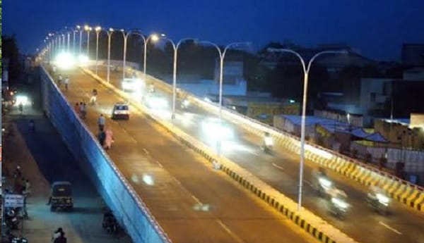
Durgapura Flyover Overview
| Detail | Information |
| Location | Durgapura, South Jaipur, Rajasthan |
| Primary Road | Tonk Road / Durgapura Junction |
| Nearest Metro Station | Durgapura — Jaipur Metro Pink Line |
| Key Roads Connected | Tonk Road, Sanganer Road, Malviya Nagar Road, Durgapura Main Road |
| Distance from City Centre (MI Road) | Approx. 6–8 km |
| Distance from Jaipur Airport | Approx. 8–10 km via Tonk Road |
| Distance from Sanganer | Approx. 5–6 km |
| Governing Authority | NHAI, PWD Rajasthan, Jaipur Development Authority |
| Nearby Landmarks | Durgapura Railway Station, Malviya Nagar Market, SMS Medical College vicinity |
| Structure Type | Elevated Road Overpass / Flyover |
| Public Transport Options | Jaipur Metro Pink Line, RSRTC Bus, City Bus, App Cabs |
| Best Suited For | South Jaipur Tonk Road and Sanganer corridor traffic |
| Peak Traffic Hours | 8:30 AM – 10:30 AM and 5:00 PM – 8:30 PM |
Directions to Durgapura Flyover
From City Centre (MI Road): Travel southward from MI Road along Tonk Road heading toward Durgapura. Continue through the Panch Batti junction and the SMS Medical College area. The flyover is approximately 6 to 8 kilometres from MI Road with a travel time of 20 to 35 minutes through Jaipur’s central and southern traffic conditions.
From Jaipur Railway Station: Travel southward from the station via the connecting arterials toward Tonk Road. Merge onto Tonk Road heading southward and continue to Durgapura approximately 7 to 9 kilometres from the station with a travel time of 25 to 40 minutes.
From Jaipur Airport (Sanganer): Exit the airport and travel northward along the airport approach road connecting to Tonk Road. Head northward toward Durgapura approximately 8 to 10 kilometres from the terminal with a travel time of 20 to 30 minutes. This route is frequently used by business travelers heading from the airport to Jaipur’s southern commercial and residential belt.
From Malviya Nagar: Travel westward from Malviya Nagar’s commercial zone via the Malviya Nagar Road connecting to Tonk Road. Approach the Durgapura Flyover from the eastern direction approximately 2 to 3 kilometres from Malviya Nagar Market, accessible within 10 to 15 minutes.
From Sanganer: Travel northward from Sanganer along Sanganer Road heading toward Durgapura. The flyover is approximately 5 to 6 kilometres from Sanganer town with a travel time of 15 to 25 minutes, making this the most direct approach for vehicles entering from the southern direction.
Metro and Public Transport Connectivity
Durgapura Metro Station on the Jaipur Metro Pink Line sits within the flyover’s immediate vicinity, connecting this southern Jaipur zone to the metro corridor that stretches from Mansarovar in the west to Badi Choupar in the east. The Pink Line gives Durgapura’s residential and commercial population direct rail access to the city center, the walled city’s commercial zones, and the important Chandpole and Sindhi Camp transit hubs without fighting the Tonk Road traffic. Jaipur City Transport Services buses and RSRTC services operate along Tonk Road through the flyover junction connecting it to Sindhi Camp Bus Station, Mansarovar, Sanganer, and the southern highway network. Auto-rickshaws and app-based cabs operate throughout the Durgapura zone providing reliable last-mile connectivity.
Road Connectivity
- Tonk Road runs north to south as Jaipur’s primary southern arterial connecting the city center to Sanganer and the Tonk-Kota highway corridor.
- Sanganer Road extends southward toward the industrial and airport zone of Sanganer.
- Malviya Nagar Road connects eastward into one of Jaipur’s most commercially active residential localities.
- Durgapura Main Road provides access into the residential interior of the Durgapura colony.
Nearby Areas and Neighbourhoods
Malviya Nagar: One of South Jaipur’s most established and commercially vibrant localities, Malviya Nagar is known for its busy market street, diverse food options, and well-developed civic infrastructure serving the large residential population of this southern belt.
Sanganer: The industrial and commercial town south of Durgapura is famous across India for its block-printing textile tradition and is home to Jaipur’s airport and several manufacturing units that generate significant commercial vehicle traffic through the Durgapura junction.
SMS Medical College Area: The Sawai Man Singh Medical College campus and the broader institutional belt it anchors along Tonk Road contributes a steady stream of students, faculty, and hospital visitors to the Durgapura corridor’s daily traffic.
Shyam Nagar and Vasant Vihar: Established southern Jaipur residential localities directly connected to the flyover via the Tonk Road secondary network, offering mid-segment housing popular among government employees and working professionals of the southern city belt.
Pratap Nagar: A rapidly developing residential zone further south toward Sanganer that has seen significant apartment development in recent years and relies on the Durgapura corridor as its primary northern connection to Jaipur’s commercial center.
Frequently Asked Questions (FAQs)
Q1. Where is Durgapura Flyover located in Jaipur?
A: It is in Durgapura, South Jaipur, on Tonk Road, approximately 6 to 8 kilometres from MI Road city centre.
Q2. Which metro station serves Durgapura Flyover?
A: Durgapura Metro Station on the Jaipur Metro Pink Line is directly adjacent to the flyover zone.
Q3. How far is Durgapura from Jaipur Airport?
A: The airport is approximately 8 to 10 kilometres from Durgapura Flyover via Tonk Road and Sanganer Road.
Q4. What residential areas are near Durgapura Flyover?
A: Malviya Nagar, Shyam Nagar, Vasant Vihar, and Pratap Nagar are the most prominent residential localities near the flyover.
Q5. Is Durgapura on the Jaipur-Tonk highway corridor?
A: Yes, Tonk Road passing through Durgapura is the primary highway artery connecting Jaipur to Tonk, Kota, and southeastern Rajasthan.