 By Ketan Kumar
 Domlur has been at the intersection of old and new Bengaluru for longer than most parts of the city can claim. It sits between the HAL aerospace heritage zone to the east and the commercial buzz of Indiranagar and Koramangala to the west and south, absorbing the traffic pressure of all these neighboring identities simultaneously. The Domlur Flyover — spanning the Old Airport Road and its connecting arterials at this busy junction — has been managing that pressure with the quiet efficiency of a structure that simply does its job without demanding attention. For the enormous population of tech workers, HAL employees, expats living in Indiranagar, and Koramangala’s startup community, the Domlur Flyover is part of the daily road grammar — unremarkable until you imagine the junction below it at peak hour without the elevated relief it provides.
The flyover’s position along the Old Airport Road corridor makes it particularly important for east Bengaluru’s connectivity to the central business district and to the Outer Ring Road network. As the areas surrounding Domlur have continued attracting corporate offices, international restaurants, fitness studios, and premium residential developments, the junction’s traffic load has grown steadily — making the flyover not just useful but genuinely essential to the corridor’s functional capacity.
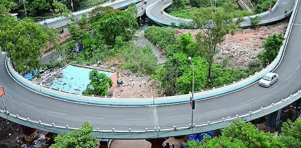
Domlur Flyover Overview
| Detail | Information |
| Location | Domlur, East Bengaluru, Karnataka |
| Primary Road | Old Airport Road / Domlur Junction |
| Nearest Metro Station | Domlur — Namma Metro Purple Line (Phase 2) |
| Key Roads Connected | Old Airport Road, Indiranagar Road, Koramangala Road, HAL Road |
| Distance from MG Road | Approx. 4–6 km |
| Distance from Whitefield | Approx. 18–20 km via Old Airport Road |
| Governing Authority | BBMP, BDA |
| Nearby Landmarks | Embassy Golf Links, Indiranagar 100 Feet Road, HAL Airport |
| Structure Type | Elevated Road Overpass / Flyover |
| Public Transport Options | Namma Metro, BMTC Bus, App Cabs, Auto-Rickshaw |
| Best Suited For | Central-east Bengaluru Old Airport Road corridor traffic |
| Peak Traffic Hours | 8:00 AM – 10:30 AM and 5:30 PM – 9:30 PM |
Directions to Domlur Flyover
From MG Road / Trinity Circle: Travel eastward from Trinity Circle along Old Airport Road. Continue through the HAL area toward Domlur. The flyover is approximately 4 to 6 kilometres from MG Road with a travel time of 15 to 25 minutes depending on traffic conditions throughout this consistently busy corridor.
From Whitefield: Take the Outer Ring Road westward from Whitefield through Marathahalli. Connect to Old Airport Road heading westward toward Domlur. Total distance is approximately 18 to 20 kilometres with a travel time of 35 to 55 minutes.
From Koramangala: Travel northward from Koramangala 5th or 7th Block via the Koramangala-Domlur linking road. The junction is approximately 3 to 4 kilometres from central Koramangala, accessible within 10 to 20 minutes by road.
From Indiranagar: Domlur is directly adjacent to Indiranagar, separated by a short 2 to 3 kilometre road stretch via CMH Road or the Old Airport Road approach. This is one of the shortest approaches to the flyover from any surrounding locality.
From Hebbal / Airport: Travel southward along NH-44 and connect to Old Airport Road via Mekhri Circle and Ulsoor Road heading eastward. Continue to Domlur. Total distance from Hebbal is approximately 12 to 15 kilometres.
Metro and Public Transport Connectivity
The Namma Metro Purple Line Phase 2 extension includes Domlur within its planned corridor, which upon completion will provide direct rail connectivity from this junction to the existing Purple Line network connecting Whitefield in the east to Mysore Road in the west. BMTC operates several routes along Old Airport Road and the Indiranagar-Koramangala cross-junction roads passing through Domlur, though the bus network in this part of Bengaluru is less dense than in the city’s more residential western zones. App-based cabs dominate the last-mile connectivity ecosystem around Domlur given the high income profile of the surrounding residential and commercial population.
Road Connectivity
- Old Airport Road runs east to west, connecting Domlur to MG Road on one end and to the Outer Ring Road and Whitefield corridor on the other.
- HAL Road extends eastward toward the Hindustan Aeronautics Limited campus and HAL Airport zone.
- Indiranagar Road connects northward into one of Bengaluru’s most upscale commercial and residential neighborhoods.
- Koramangala Road links southward into the Koramangala startup and residential belt.
Nearby Areas and Neighbourhoods
Indiranagar: Bengaluru’s most celebrated cosmopolitan neighborhood, Indiranagar is immediately north of Domlur and offers the city’s densest concentration of premium restaurants, craft breweries, fashion boutiques, fitness studios, and a thriving expat community.
Koramangala: South of Domlur, Koramangala is India’s most prominent startup ecosystem locality, housing hundreds of tech startups, venture capital offices, and the residential communities that support them.
Embassy Golf Links: One of Bengaluru’s most prestigious IT parks, Embassy Golf Links is located directly adjacent to the Domlur junction area and employs thousands of technology professionals who use the flyover as their primary daily commute route.
HAL Heritage Zone: The Hindustan Aeronautics Limited campus and its surrounding institutional zone lies east of Domlur, representing an important aerospace and defence industry presence that has shaped the area’s character for decades.
Intermediate Ring Road Corridor: Residential and commercial developments along the Intermediate Ring Road near Domlur include premium apartments, corporate guest houses, and retail establishments serving the high-income professional population of this east Bengaluru corridor.
Frequently Asked Questions (FAQs)
Q1. Where is Domlur Flyover located in Bengaluru?
A: It is at Domlur junction on Old Airport Road in East Bengaluru, approximately 4 to 6 kilometres from MG Road.
Q2. Which IT parks are closest to Domlur Flyover?
A: Embassy Golf Links is the most prominent IT park directly adjacent to the Domlur junction area.
Q3. How far is Domlur Flyover from Whitefield?
A: Domlur is approximately 18 to 20 kilometres from Whitefield via Old Airport Road and the Outer Ring Road.
Q4. What are the best residential areas near Domlur Flyover?
A: Indiranagar, Koramangala, and the HAL 2nd Stage area are the most sought-after residential localities near the flyover.
Q5. Is there metro connectivity at Domlur Flyover?
A: The Namma Metro Purple Line Phase 2 extension plans include a Domlur station that will provide direct rail access to this junction.