 By Ketan Kumar
 Dehradun occupies a very specific geographic and emotional place in the Indian imagination — a hill station gateway, an educational city of considerable prestige, a retirement destination of long-standing appeal, and increasingly a technology and government administrative hub as Uttarakhand’s capital continues maturing into its institutional role. The city’s road infrastructure has had to evolve rapidly to serve these multiple identities simultaneously, managing the traffic of tourists heading to Mussoorie, government employees commuting to the secretariat, students attending the dozens of reputed institutions that give Dehradun its academic character, and the everyday residential traffic of a fast-growing hill city whose topography imposes natural constraints on expansion.
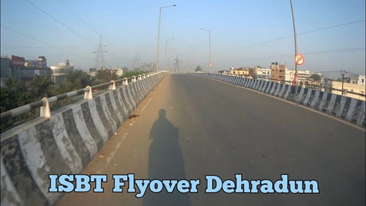
The ISBT Flyover near Dehradun’s Inter-State Bus Terminal sits at one of the city’s most important transit nodes, spanning a junction that manages the convergence of bus terminal traffic, national highway movement on the Delhi-Dehradun corridor, and the internal city road network feeding into the commercial and residential zones surrounding this busy zone. For the thousands of daily commuters, inter-state travelers, and local residents whose journeys begin or pass through this junction, the flyover provides the elevated relief that keeps Dehradun’s most traffic-intensive gateway functional during the peak hours that the ISBT’s operations inevitably generate.
| Detail | Information |
| Location | ISBT Area, Dehradun, Uttarakhand |
| Primary Road | Haridwar Road (NH-58) / Saharanpur Road |
| Nearest Railway Station | Dehradun Railway Station — Approx. 3–4 km |
| Nearest Airport | Jolly Grant Airport — Approx. 28–30 km |
| Key Roads Connected | Haridwar Road (NH-58), Saharanpur Road, Rajpur Road connector, Delhi Road |
| Distance from Clock Tower | Approx. 3–4 km |
| Distance from Mussoorie | Approx. 33–35 km via Rajpur Road |
| Distance from Haridwar | Approx. 50 km via NH-58 |
| Governing Authority | NHAI, PWD Uttarakhand, Dehradun Municipal Corporation |
| Nearby Landmarks | ISBT Dehradun, Doiwala Road, Gandhi Road Commercial Belt |
| Structure Type | Elevated Road Overpass / Flyover |
| Public Transport Options | UPSRTC/GMOU Bus, City Bus, App Cabs, Vikram Tempo |
| Best Suited For | Dehradun ISBT approach and Haridwar Road national highway traffic |
| Peak Traffic Hours | 7:30 AM – 10:30 AM and 4:30 PM – 8:00 PM |
Directions to ISBT Flyover
From Dehradun Clock Tower: Travel southward from Dehradun’s iconic Clock Tower along Gandhi Road heading toward the ISBT zone. Continue approximately 3 to 4 kilometres through the city’s commercial belt toward the ISBT area. Travel time is approximately 15 to 25 minutes through Dehradun’s central traffic, which manages to combine hill city charm with genuinely urban congestion during peak hours.
From Dehradun Railway Station: Exit the station and travel eastward via the station road heading toward the ISBT zone. The flyover area is approximately 3 to 4 kilometres from the railway station with a travel time of 10 to 20 minutes. This short connection makes the rail-to-bus transfer at ISBT one of the more convenient intermodal transitions for travelers arriving by train.
From Delhi via NH-58: Travel northward along NH-58 from Delhi through Saharanpur and Roorkee heading toward Dehradun. The ISBT Flyover is encountered as one of the first major elevated structures upon entering Dehradun’s urban boundary from the southern highway direction. Total distance from Delhi is approximately 285 to 300 kilometres with a travel time of 5 to 6 hours.
From Haridwar: Travel northward along NH-58 from Haridwar heading toward Dehradun. Continue along the highway through Doiwala and approach the ISBT zone from the southeastern direction. Total distance from Haridwar is approximately 50 kilometres with a travel time of 60 to 80 minutes depending on the highway conditions through the Dehradun valley approach.
From Mussoorie: Travel southward from Mussoorie along Rajpur Road heading toward Dehradun city center. Continue through the Rajpur Road commercial belt and connect to the ISBT area via the city center junction. Total distance from Mussoorie is approximately 33 to 35 kilometres with a travel time of 50 to 70 minutes through the mountain road descent.
Metro and Public Transport Connectivity
Dehradun does not currently have an operational metro system, though urban transport planning for the city includes future rapid transit considerations as the population and traffic continue growing. The ISBT itself serves as the city’s primary public transport hub — Uttarakhand Transport Corporation buses, GMOU services, and inter-state operators connect Dehradun via ISBT to Delhi, Haridwar, Rishikesh, Mussoorie, Chandigarh, and dozens of Uttarakhand hill destinations. Dehradun’s city bus services and the iconic Vikram tempos — the shared three-wheelers that form the backbone of intra-city public transport in hill cities — connect the ISBT Flyover area to the Clock Tower, Railway Station, Paltan Bazar, and the broader city network. App-based cabs have seen growing adoption in Dehradun’s urban core, particularly among tourists and the city’s growing professional population.
Road Connectivity
- Haridwar Road (NH-58) runs southeast toward Haridwar, Roorkee, and the national highway network connecting Dehradun to Delhi.
- Saharanpur Road provides an alternative highway approach connecting Dehradun to Saharanpur and the UP plains network.
- Delhi Road extends southward as the primary city road alignment heading toward the Delhi-bound highway approaches.
- Rajpur Road connector links the ISBT zone northward toward Rajpur Road’s premium residential and commercial belt heading toward Mussoorie.
Nearby Areas and Neighbourhoods
ISBT Dehradun: The Inter-State Bus Terminal is the primary reason for the flyover’s existence and remains the dominant functional landmark of this junction zone, processing thousands of passengers daily across bus services to Delhi, hill stations, and destinations across Uttarakhand and neighboring states.
Gandhi Road Commercial Belt: The commercial strip extending from the ISBT zone toward Dehradun’s Clock Tower is one of the city’s most active retail and service corridors, housing banks, shops, restaurants, and travel agencies that serve both local residents and the transit population passing through the ISBT.
Doiwala: A town on the highway approximately 15 kilometres southeast of Dehradun, Doiwala is an important feeder community for the ISBT zone and contributes a significant proportion of the daily commuter traffic using the NH-58 approach to the flyover.
Patel Nagar and Niranjanpur: Established residential localities within Dehradun’s expanding urban perimeter that are connected to the ISBT flyover zone via the city’s road network and serve as housing areas for government employees, teachers, and the working professional population.
Rispana River Zone: The Rispana River’s course through Dehradun’s urban fabric passes near the ISBT zone, and the floodplain areas along its banks have been the subject of ongoing urban development regulation and environmental protection efforts that shape land use patterns in this part of the city.
Frequently Asked Questions (FAQs)
Q1. Where is ISBT Flyover located in Dehradun?
It is near the Inter-State Bus Terminal on Haridwar Road in Dehradun, approximately 3 to 4 kilometres from both the Clock Tower and the Railway Station.
Q2. How far is ISBT Flyover from Jolly Grant Airport?
Jolly Grant Airport is approximately 28 to 30 kilometres from ISBT Flyover, with a travel time of 40 to 55 minutes via NH-58.
Q3. What public transport options are available at ISBT Flyover?
Uttarakhand Transport Corporation buses, GMOU services, city buses, Vikram tempos, and app-based cabs all serve the ISBT junction area.
Q4. How far is ISBT Dehradun from Mussoorie?
Mussoorie is approximately 33 to 35 kilometres from ISBT via Rajpur Road, with a travel time of 50 to 70 minutes.
Q5. Is Dehradun Railway Station near ISBT Flyover?
Yes, Dehradun Railway Station is approximately 3 to 4 kilometres from the ISBT Flyover, making the rail-to-bus transfer at this transit node reasonably convenient.