 By Ketan Kumar
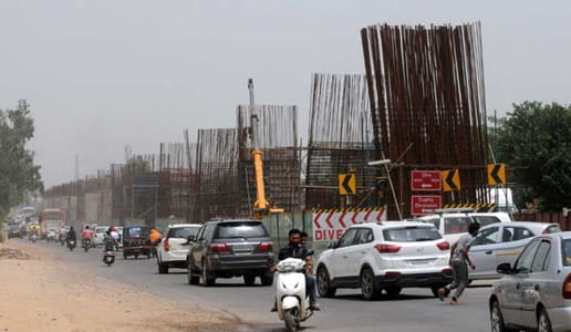
 The tricity region of Chandigarh, Mohali, and Panchkula has been generating residential and commercial growth pressure in all directions, and the towns along its outer ring have borne the brunt of that expansion with varying degrees of preparedness. Kharar has been one of the more consequential of these peripheral towns — sitting directly north of Mohali along the Chandigarh-Ropar highway corridor, it has grown from a modest Punjab town into a substantial suburban satellite that now houses a very significant proportion of the tricity region’s IT and government employee residential population. The Kharar Flyover spans one of the town’s most congested junction points along the NH-205 corridor, providing the elevated through-passage that allows the primary Chandigarh-Ropar highway traffic to move without being absorbed into the complex local traffic geometry of a town junction that manages far more daily vehicle movement than its original infrastructure was ever designed for.
Kharar’s growth story is directly tied to housing affordability — professionals working in Chandigarh’s government offices, Mohali’s IT parks, and the IIT and PGI complexes have increasingly chosen Kharar for its lower property prices, newer construction, and the better living space that slightly greater distance from the tricity’s premium zones allows. That residential choice multiplied across thousands of families has created the daily commuter volume that the Kharar Flyover now helps manage. For every professional who chose Kharar’s affordable apartments over Mohali’s higher-priced sectors, the flyover’s smooth functioning is a small but daily dividend on that investment decision.
| Detail | Information |
| Location | Kharar, SAS Nagar District, Punjab |
| Primary Road | NH-205 / Chandigarh-Ropar Highway |
| Nearest Railway Station | Chandigarh Railway Station — Approx. 18–20 km |
| Nearest Airport | Chandigarh International Airport — Approx. 15–17 km |
| Key Roads Connected | NH-205, Kharar-Landran Road, Mohali Road, Ropar Road |
| Distance from Chandigarh | Approx. 14–16 km via NH-205 |
| Distance from Mohali | Approx. 10–12 km |
| Distance from Zirakpur | Approx. 20–22 km |
| Governing Authority | NHAI, Punjab PWD, Kharar Municipal Council |
| Nearby Landmarks | Kharar Bus Stand, Landran IT Hub, IIT Ropar Road |
| Structure Type | Elevated Road Overpass / Flyover |
| Public Transport Options | PUNBUS, PRTC Bus, CTU Bus, App Cabs, Auto-Rickshaw |
| Best Suited For | Chandigarh-Ropar highway and Kharar town local traffic |
| Peak Traffic Hours | 8:00 AM – 10:30 AM and 5:00 PM – 8:30 PM |
Directions to Kharar Flyover
From Chandigarh: Travel northward from Chandigarh’s Sector 17 or the ISBT along NH-205 heading toward Kharar. Continue along the highway through the Chandigarh-Mohali peripheral zones. Kharar Flyover is approximately 14 to 16 kilometres from Chandigarh with a travel time of 25 to 40 minutes depending on the morning commuter traffic on this consistently busy corridor.
From Mohali: Travel northward from Mohali’s Phase 10 or Phase 11 area via the Mohali-Kharar Road heading toward the NH-205 corridor. Kharar Flyover is approximately 10 to 12 kilometres from central Mohali with a travel time of 20 to 35 minutes through the outer Mohali road network.
From Ropar: Travel southwestward from Ropar along NH-205 heading toward Chandigarh. Kharar Flyover is the primary elevated junction encountered on the approach to the tricity region from the Ropar direction, approximately 35 to 40 kilometres from Ropar town center.
From Chandigarh Airport: Exit the airport and connect to NH-205 heading northward toward Kharar. Continue along the highway approximately 15 to 17 kilometres from the airport with a travel time of 25 to 40 minutes through the northern suburban corridor.
From Landran: Travel southwestward from the Landran area — home to several engineering colleges and the developing Landran IT Hub — via Kharar-Landran Road heading toward the Kharar junction. The flyover is approximately 4 to 5 kilometres from Landran with a travel time of 10 to 20 minutes through this rapidly urbanizing northern corridor.
Metro and Public Transport Connectivity
Kharar does not currently have metro connectivity, and the planned Chandigarh Metro project’s extension toward the tricity’s northern suburban belt remains in future planning stages. PUNBUS and PRTC buses operate along NH-205 connecting Kharar to Chandigarh ISBT, Ropar, Morinda, and other Punjab destinations with reasonable frequency for a town of Kharar’s scale. Chandigarh Transport Undertaking (CTU) runs some services from Chandigarh that extend into Kharar for the large commuter population working in the planned city. Auto-rickshaws serve intra-Kharar movement extensively, and app-based cabs have seen very strong adoption among the town’s large professional residential population whose daily work commute toward Chandigarh and Mohali makes cab-based transport a practical daily necessity.
Road Connectivity
- NH-205 runs north to south as the primary Chandigarh-Ropar highway carrying both intercity and daily commuter traffic through the Kharar junction.
- Kharar-Landran Road extends eastward toward the Landran educational and emerging IT corridor.
- Mohali Road connects southward toward Mohali’s sector road network and the IT park zone.
- Ropar Road extends northward toward the Ropar industrial and administrative zone along the Sutlej River corridor.
Nearby Areas and Neighbourhoods
Landran: An educational township immediately east of Kharar, Landran hosts several engineering and management colleges and has been designated as part of Mohali’s IT and institutional expansion zone. The large student and faculty population contributes substantially to the Kharar junction’s daily traffic.
Kurali: A small Punjab town north of Kharar along NH-205, Kurali serves as an important commercial stop for highway travelers and its population uses the Kharar corridor as their primary access point to the tricity region’s employment and commercial opportunities.
Mohali Phases 10 and 11: The northernmost residential phases of Mohali sit within comfortable commuting distance of the Kharar flyover and represent the transition zone between Mohali’s planned sector development and Kharar’s more organically grown residential expansion.
Sector 125 and Aerocity Mohali: The newer institutional and commercial developments of Mohali’s northern sectors are connected to the Kharar corridor via the Mohali-Kharar Road and represent growing employment destinations for Kharar’s residential population.
Nayagaon: A large residential locality between Kharar and Chandigarh’s northern boundary, Nayagaon has grown substantially as a transitional settlement absorbing residents who work in Chandigarh but prefer Nayagaon or Kharar’s more affordable housing.
Frequently Asked Questions (FAQs)
Q1. Where is Kharar Flyover located in Punjab?
It is in Kharar, SAS Nagar District, Punjab, on NH-205 (Chandigarh-Ropar Highway), approximately 14 to 16 kilometres from Chandigarh.
Q2. How far is Kharar Flyover from Chandigarh Airport?
Chandigarh International Airport is approximately 15 to 17 kilometres from the flyover via NH-205.
Q3. Is there metro connectivity at Kharar Flyover?
Kharar does not currently have metro connectivity. PUNBUS, PRTC, CTU buses, and app-based cabs provide public transport coverage.
Q4. What educational institutions are near Kharar Flyover?
The Landran educational township with several engineering and management colleges is approximately 4 to 5 kilometres east of the flyover via Kharar-Landran Road.
Q5. How far is Kharar from Mohali?
Mohali is approximately 10 to 12 kilometres south of Kharar Flyover via the Mohali-Kharar Road corridor.