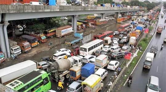
Palam carries layers of history that most Delhi neighborhoods can only gesture toward. It was the site of Delhi’s original civilian airport before Indira Gandhi International Airport was developed into its current form, it houses one of the Indian Air Force’s most important operational bases, and it sits at the center of one of southwestern Delhi’s most densely populated and historically embedded residential communities. The Palam Flyover spans a junction that reflects all of this layered complexity — a busy crossing where the traffic of an air force cantonment town, a large civilian residential locality, and the approach roads to India’s busiest airport must all negotiate space simultaneously.
For the large and diverse population of Palam — which includes Air Force personnel and their families, government employees, long-established residential communities, and the newer commercial establishments that have grown up around the airport economy — the flyover provides the elevated through-passage that keeps daily movement functional. The junction it spans connects roads leading toward the airport, Dwarka, Dabri, and Uttam Nagar, making it a genuinely multi-directional node whose smooth functioning has real consequences for a wide catchment of daily commuters in southwestern Delhi.
Palam Flyover Overview
| Detail | Information |
| Location | Palam, South-West Delhi |
| Primary Road | Palam Road / Dwarka-Palam Road |
| Nearest Metro Station | Palam — Delhi Metro Blue Line |
| Key Roads Connected | Palam Road, Dwarka Road, Dabri Road, Uttam Nagar Road, Airport Road |
| Distance from IGI Airport | Approx. 3–5 km |
| Distance from Dwarka | Approx. 6–8 km |
| Distance from Dabri Mor | Approx. 3–4 km |
| Governing Authority | PWD Delhi, NHAI, DMRC |
| Nearby Landmarks | Palam Air Force Station, Bharat Vihar, Sadh Nagar |
| Structure Type | Elevated Road Overpass / Flyover |
| Public Transport Options | Delhi Metro Blue Line, DTC Bus, App Cabs, Auto-Rickshaw |
| Best Suited For | Airport approach and South-West Delhi Palam corridor traffic |
| Peak Traffic Hours | 7:00 AM – 10:00 AM and 5:30 PM – 9:00 PM |
Directions to Palam Flyover
From Connaught Place / Central Delhi: Travel southwestward via Panchkuian Road or Outer Ring Road heading toward Dhaula Kuan. Continue southward through Vasant Vihar and Vasant Kunj toward Palam. Alternatively, use NH-48 and exit toward the Palam Road connector. Total distance from Connaught Place is approximately 20 to 22 kilometres with a travel time of 40 to 60 minutes.
From IGI Airport: Exit the airport terminals and take the airport service road heading northward toward Palam. The flyover is approximately 3 to 5 kilometres from the terminal areas, making it one of the most frequently used elevated structures by airport-adjacent commuters living in Palam and Dabri.
From Dwarka: Travel southeastward from Dwarka via the Dwarka-Palam Road heading toward the Palam junction. The flyover is approximately 6 to 8 kilometres from Dwarka’s central sectors with a travel time of 20 to 30 minutes through the residential road network.
From Dabri Mor: Travel southward from Dabri Mor along Dabri Road heading toward Palam. The flyover is approximately 3 to 4 kilometres from Dabri Mor with a travel time of 10 to 15 minutes. This is a commonly used approach for residents of Uttam Nagar and Dabri heading toward the airport zone.
From Najafgarh: Travel northeastward from Najafgarh along Najafgarh Road heading toward Delhi’s southwestern arterials. Connect to Palam Road and approach the flyover from the western direction. Total distance from Najafgarh is approximately 12 to 15 kilometres with a travel time of 25 to 40 minutes.
Metro and Public Transport Connectivity
Palam Metro Station on the Delhi Metro Blue Line is the nearest rail access point to the flyover, connecting the Palam area eastward through Dwarka Mor, Uttam Nagar, Janakpuri, Rajouri Garden, and all the way to Noida across Delhi’s east-west metro spine. The Blue Line interchange with the Airport Express Line at Dwarka Sector 21 — accessible from Palam Metro in a few stops — provides airport travelers with a rapid rail option to New Delhi Railway Station. DTC buses operate multiple routes through the Palam Road and Dabri Road corridors, connecting the flyover area to Dwarka, Uttam Nagar, and the broader western Delhi bus network. Auto-rickshaws operate extensively within the Palam and surrounding locality for shorter intra-area movements, and app-based cabs are well-available in this airport-adjacent corridor.
Road Connectivity
- Palam Road runs through the heart of Palam locality connecting the flyover to the airport approach roads and the cantonment zone.
- Dwarka Road extends northwestward toward Dwarka’s residential sectors.
- Dabri Road connects northward toward Dabri Mor and Uttam Nagar’s residential belt.
- Airport Road links the flyover directly to IGI Airport’s terminal approach roads.
Nearby Areas and Neighbourhoods
Palam Air Force Station: The Indian Air Force’s operational base at Palam is one of the most significant defence installations in the National Capital Region, and the flyover’s daily traffic includes a substantial proportion of Air Force personnel and civilian employees associated with the base.
Sadh Nagar: One of Palam’s most established residential colonies, Sadh Nagar is a densely populated community with strong local market infrastructure, schools, and the kind of long-established neighborhood character that gives this part of southwestern Delhi its distinct identity.
Bharat Vihar: A well-developed residential locality near the flyover, Bharat Vihar offers mid-segment apartment housing and plotted developments that attract families working in Dwarka, Gurugram, and the airport zone.
Palam Village: The original urban village at the core of Palam’s history, Palam Village has been absorbed into Delhi’s urban fabric while retaining some of its original community character — a mix of older housing, local commercial streets, and community spaces that newer planned localities rarely replicate.
Dabri and Uttam Nagar: The densely populated residential localities of Dabri and Uttam Nagar lie north of the flyover and are directly connected via Dabri Road, contributing a significant proportion of the daily traffic that passes through Palam junction.
Frequently Asked Questions (FAQs)
Q1. Where is Palam Flyover located in Delhi?
A: It is in Palam, South-West Delhi, on Palam Road, approximately 3 to 5 kilometres from IGI Airport terminals.
Q2. Which metro station is nearest to Palam Flyover?
A: Palam Metro Station on the Delhi Metro Blue Line is the nearest station, providing east-west metro connectivity across Delhi.
Q3. How far is Palam Flyover from Dwarka?
A: The flyover is approximately 6 to 8 kilometres from Dwarka’s central sectors via the Dwarka-Palam Road.
Q4. Is Palam Flyover on the route to IGI Airport?
A: Yes, the flyover is approximately 3 to 5 kilometres from IGI Airport and is part of the primary local access route from Palam and Dabri toward the terminal areas.
Q5. Which residential areas are near Palam Flyover?
A: Sadh Nagar, Bharat Vihar, Palam Village, Dabri, and Uttam Nagar are the most prominent residential localities near the Palam Flyover.