 By Ketan Kumar
 The Silk Board Flyover is arguably the most talked-about and notorious traffic junction in all of Bengaluru, Karnataka. Located in the southeastern part of the city at the intersection of Hosur Road (NH-44) and the Outer Ring Road (ORR), this elevated structure sits at one of India’s most congested urban crossings, earning Silk Board a near-legendary status among daily commuters across the country. Despite being a flyover designed to ease traffic movement, the sheer volume of vehicles converging at this junction — from IT professionals, logistics operators, airport travelers, and inter-city commuters — makes it a defining experience of Bengaluru’s urban mobility landscape.
The Silk Board junction derives its name from the Karnataka Silk Industries Corporation office historically located in the area. Over the decades, as Bengaluru expanded southward and eastward into Electronic City, Whitefield, Sarjapur Road, and HSR Layout, the Silk Board junction became the unavoidable meeting point of all these growth corridors. The flyover was constructed to provide some relief to this impossible convergence, and while it has improved traffic flow considerably, the junction remains a significant daily challenge for hundreds of thousands of commuters. For IT workers, real estate investors, business owners, and new residents of South and South-East Bengaluru, understanding the Silk Board Flyover’s directions, connectivity, and surrounding areas is absolutely fundamental to planning life and work in India’s Silicon Valley.
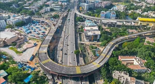
Silk Board Flyover Overview
| Detail | Information |
| Location | Silk Board Junction, South-East Bengaluru, Karnataka |
| Primary Roads | Hosur Road (NH-44), Outer Ring Road |
| Nearest Metro Station | Silk Board — Namma Metro Green Line (Phase 2) |
| Key Roads Connected | NH-44, ORR, Hosur Road, Sarjapur Road, BTM Layout Road |
| Distance from City Centre | Approx. 12–14 km from MG Road |
| Distance from Electronic City | Approx. 8–10 km via Hosur Road |
| Governing Authority | BBMP, NHAI, BDA |
| Nearby Tech Parks | Embassy Tech Village, RMZ Ecospace, Salarpuria Softzone |
| Structure Type | Elevated Road Overpass / Flyover |
| Public Transport Options | Namma Metro, BMTC Bus, App Cabs, Auto-Rickshaw |
| Best Suited For | South and South-East Bengaluru corridor traffic |
| Peak Traffic Hours | 8:00 AM – 10:30 AM and 5:30 PM – 9:30 PM |
Directions to Silk Board Flyover
From MG Road / City Centre: Take the Outer Ring Road from Trinity Circle heading southeast. Continue along the ORR through Domlur, Marathahalli connector, and BTM Layout. Silk Board Junction is approximately 12 to 14 kilometres ahead. Alternatively, take Hosur Road from Richmond Circle heading south and continue directly to Silk Board. Travel time is 30 to 50 minutes depending on traffic.
From Electronic City: Travel northward along Hosur Road (NH-44) from Electronic City Phase 1 or Phase 2. Silk Board Flyover is approximately 8 to 10 kilometres ahead and is the first major flyover junction encountered while heading toward the city centre.
From Whitefield: Take the Outer Ring Road westward from Whitefield through Marathahalli and Bellandur. Continue along the ORR heading southwest toward Silk Board. The journey covers approximately 20 to 25 kilometres and takes 45 to 75 minutes during peak hours.
From Sarjapur Road: Head westward from Sarjapur Road via Agara or HSR Layout. Connect to the Outer Ring Road heading northwest and approach Silk Board from the eastern side. This route is extensively used by residents of Sarjapur Road’s densely populated residential corridors.
From Hebbal / Airport: Take NH-44 southward from Hebbal through Mekhri Circle and the city center. Continue along Hosur Road heading south past Lalbagh and Dairy Circle. Silk Board Flyover is approximately 25 to 30 kilometres from Hebbal with a travel time of 60 to 90 minutes.
Metro and Public Transport Connectivity
The Namma Metro Green Line Phase 2 extension includes a dedicated Silk Board Metro Station, which upon full operation will dramatically transform public transport accessibility at this junction. The metro connectivity will provide a fast, signal-free alternative for thousands of IT professionals and daily commuters currently stuck in road traffic.
BMTC operates some of its highest-frequency bus routes through Silk Board, connecting it to Majestic, Shivajinagar, Electronic City, Whitefield, and HSR Layout. Several Volvo Air-conditioned services also run through this corridor. App-based cabs dominate the last-mile travel ecosystem around Silk Board, with auto-rickshaws serving shorter intra-neighbourhood trips.
Road Connectivity
The Silk Board Flyover sits at the convergence of Bengaluru’s most critical road networks:
- NH-44 (Hosur Road) runs south toward Electronic City, Hosur, and Chennai.
- Outer Ring Road connects circumferentially to Whitefield, Marathahalli, Bellandur, and HSR Layout.
- Sarjapur Road extends eastward toward one of Bengaluru’s fastest-growing residential and commercial corridors.
- BTM Layout Road provides access to inner South Bengaluru’s residential zones.
Nearby Areas and Neighbourhoods
HSR Layout: One of Bengaluru’s most desirable residential and startup ecosystem neighbourhoods, HSR Layout is located immediately adjacent to the Silk Board junction and offers a vibrant mix of apartments, villas, cafes, co-working spaces, and tech offices.
BTM Layout: A densely populated and commercially active residential area south of Silk Board, BTM Layout is popular among IT professionals for its affordable housing, abundant restaurants, and excellent connectivity.
Bellandur: Home to Embassy Tech Village, RMZ Ecospace, and several other premium IT campuses, Bellandur is directly connected to Silk Board via the ORR and represents one of Bengaluru’s most important tech employment zones.
Electronic City: Bengaluru’s original IT hub, housing Infosys, Wipro, and hundreds of technology companies, is directly south of Silk Board along Hosur Road. The flyover is the primary entry and exit point for Electronic City commuters heading toward the city.
Koramangala: One of Bengaluru’s most premium and cosmopolitan neighbourhoods, Koramangala is accessible from Silk Board via Hosur Road and offers upscale residential options, top restaurants, and a thriving startup and entrepreneurial community.
Bommanahalli and Kudlu Gate: These rapidly developing localities along Hosur Road between Silk Board and Electronic City offer mid-segment and affordable housing attracting a young professional population working in nearby tech parks.
Frequently Asked Questions (FAQs)
Q1. Why is Silk Board so notorious for traffic congestion?
A: Silk Board sits at the intersection of Hosur Road and the Outer Ring Road — two of Bengaluru’s busiest corridors — creating a massive daily convergence of IT commuter, inter-city, and local traffic.
Q2. Is there a metro station at Silk Board?
A: Yes, Silk Board Metro Station on the Namma Metro Green Line Phase 2 is planned and under development to serve this junction directly.
Q3. Which IT parks are closest to Silk Board Flyover?
A: Embassy Tech Village, RMZ Ecospace in Bellandur, and Salarpuria Softzone along Hosur Road are the closest major tech campuses.
Q4. What residential areas are best near Silk Board Flyover?
A: HSR Layout, Koramangala, BTM Layout, and Bellandur are the most popular and well-connected residential localities near Silk Board.
Q5. How far is Electronic City from Silk Board Flyover?
A: Electronic City is approximately 8 to 10 kilometres from Silk Board via Hosur Road, with a travel time of 20 to 40 minutes depending on traffic.