 By Ketan Kumar
 Western Chennai has been growing in ways that were not fully anticipated even a decade ago. The corridor stretching from Guindy through Vadapalani toward Porur and Poonamallee has evolved from a semi-industrial highway stretch into one of the city’s most commercially and residentially active western zones, driven by the expansion of IT parks along Old Mahabalipuram Road’s parallel corridors, the growth of premium residential projects along Porur Lake, and the steady westward march of Chennai’s middle-class population seeking more affordable housing options than the city’s saturated southern and central localities can offer. Porur sits at the hinge of this westward expansion, and the flyover spanning its main junction manages the traffic consequences of that growth with the practical efficiency that a junction of this daily importance demands.
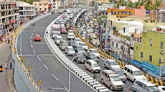
The Porur Flyover spans one of Chennai’s most strategically significant western junctions — the point where the Chennai Bypass Road and the Mount-Poonamallee High Road intersect, creating a crossing that handles not just city traffic but the substantial volume of national highway movement using the bypass to avoid Chennai’s interior congestion. For the large residential population of Porur, Mugalivakkam, Ramapuram, and Kundrathur, and for the technology professionals working in the IT parks along the Sholinganallur and Porur corridor, this flyover is a daily fixture that shapes how western Chennai moves.
| Detail | Information |
| Location | Porur, West Chennai, Tamil Nadu |
| Primary Road | Mount-Poonamallee High Road / Chennai Bypass Road (NH-48) |
| Nearest Metro Station | Porur — Chennai Metro Green Line (Phase 2) |
| Key Roads Connected | Mount-Poonamallee High Road, Chennai Bypass (NH-48), Arcot Road, Kundrathur Road |
| Distance from City Centre (Egmore) | Approx. 18–20 km |
| Distance from Chennai Airport | Approx. 10–12 km via Bypass Road |
| Distance from Vadapalani | Approx. 8–10 km |
| Governing Authority | Greater Chennai Corporation (GCC), NHAI, Tamil Nadu PWD |
| Nearby Landmarks | Porur Lake, DLF IT Park, Ramapuram, VGN Township |
| Structure Type | Elevated Road Overpass / Flyover |
| Public Transport Options | Chennai Metro Phase 2, MTC Bus, App Cabs, Auto-Rickshaw |
| Best Suited For | West Chennai bypass corridor and Mount-Poonamallee Road traffic |
| Peak Traffic Hours | 8:30 AM – 10:30 AM and 5:30 PM – 9:00 PM |
Directions to Porur Flyover
From Egmore / City Centre: Travel westward from Egmore via Poonamallee High Road heading toward Vadapalani and Koyambedu. Continue westward through Valasaravakkam and approach Porur approximately 18 to 20 kilometres from the city center. Travel time is approximately 40 to 60 minutes through Chennai’s western corridor traffic.
From Chennai Airport: Exit the airport and connect to the Bypass Road (NH-48) heading southwestward. Continue along the bypass toward the Porur junction. Total distance from the airport is approximately 10 to 12 kilometres with a travel time of 20 to 35 minutes — making this one of the more important approaches for travelers using the western bypass to reach Porur without entering the city center.
From Vadapalani: Travel westward from Vadapalani along the Mount-Poonamallee High Road heading toward Porur. Continue through Virugambakkam and Valasaravakkam. Porur Flyover is approximately 8 to 10 kilometres from Vadapalani with a travel time of 25 to 40 minutes.
From Kundrathur / Sriperumbudur: Travel eastward from Kundrathur along the Kundrathur Road heading toward Porur. Approach the flyover from the southwestern direction via the Kundrathur-Porur connector. This route is used by residents of the expanding southwestern suburban belt and by workers from the Sriperumbudur industrial corridor.
From Koyambedu: Travel westward from Koyambedu CMBT along the Mount-Poonamallee High Road heading toward Porur. Continue approximately 8 to 10 kilometres through the western Chennai corridor. The flyover is directly accessible via this well-maintained road with a travel time of 20 to 35 minutes depending on traffic.
Metro and Public Transport Connectivity
The Chennai Metro Green Line Phase 2 extension into western Chennai includes Porur within its planned corridor, which upon completion will provide the western residential belt with the rail connectivity it has been functioning without for the entirety of its rapid growth period. This metro extension is among the most eagerly anticipated public transport developments for western Chennai’s large professional and residential population. MTC buses operate several routes along the Mount-Poonamallee High Road and the Bypass Road through Porur, connecting it to Koyambedu CMBT, Vadapalani, Guindy, and the broader Chennai bus network. The frequency on the MTC routes serving this corridor is among the more reliable in western Chennai given the high residential density of the surrounding localities. Auto-rickshaws and app-based cabs serve the shorter intra-locality movements and last-mile connectivity throughout the day.
Road Connectivity
- Mount-Poonamallee High Road runs east to west connecting Chennai’s inner suburban belt to Porur and further westward toward Poonamallee and Sriperumbudur.
- Chennai Bypass Road (NH-48) provides national highway connectivity northward toward the airport and southward toward Walajapet and the Bengaluru corridor.
- Arcot Road extends westward from the Porur junction toward Valasaravakkam and the Mugalivakkam residential belt.
- Kundrathur Road connects southwestward toward the Kundrathur and Peerkankaranai semi-urban belt.
Nearby Areas and Neighbourhoods
Porur Lake: One of Chennai’s most significant urban water bodies, Porur Lake sits adjacent to the flyover junction and provides an ecological and recreational anchor within a zone that has seen considerable construction pressure from the residential and commercial development on its banks.
Ramapuram: A well-established and rapidly growing residential locality south of the flyover, Ramapuram has seen substantial apartment development driven by its position along the NH-48 corridor and its reasonable proximity to the city’s southern IT parks via the bypass road.
Mugalivakkam: An emerging residential locality west of Porur along Arcot Road, Mugalivakkam offers affordable to mid-segment housing that has attracted a young professional population working in the western Chennai IT corridor.
DLF IT Park Porur: The DLF technology park near Porur is one of the western Chennai IT corridor’s most significant employers, housing technology companies and contributing substantially to the professional commuter traffic that passes through the Porur Flyover daily.
Valasaravakkam: One of western Chennai’s most densely populated residential localities, Valasaravakkam offers a mix of independent houses and apartment developments with strong local market infrastructure and MTC bus connectivity that serves a large middle-class residential population.
Frequently Asked Questions (FAQs)
Q1. Where is Porur Flyover located in Chennai?
A: It is in Porur, West Chennai, at the junction of Mount-Poonamallee High Road and Chennai Bypass Road, approximately 18 to 20 kilometres from Egmore.
Q2. Which metro station will serve Porur Flyover?
A: Porur is planned as part of the Chennai Metro Green Line Phase 2 extension into western Chennai.
Q3. How far is Porur Flyover from Chennai Airport?
A: The airport is approximately 10 to 12 kilometres from Porur via the Chennai Bypass Road (NH-48).
Q4. What IT parks are near Porur Flyover?
A: DLF IT Park Porur is the most prominent technology campus near the flyover, employing a significant number of IT professionals from the surrounding western Chennai residential belt.
Q5. What residential areas are near Porur Flyover?
A: Ramapuram, Mugalivakkam, Valasaravakkam, and the areas surrounding Porur Lake are the most prominent residential localities near the flyover.